You are here: Home > Network List > GT - Global Telemetered Seismograph Network (USAF/USGS) Stations List
> Station CPUP Villa Florida, Paraguay > Earthquake Result Viewer
CPUP Villa Florida, Paraguay - Earthquake Result Viewer

| Earthquake location: |
Puerto Rico Region |
| Earthquake latitude/longitude: |
19.0/-66.8 |
| Earthquake time(UTC): |
2014/01/13 (013) 04:01:03 GMT |
| Earthquake Depth: |
20 km |
| Earthquake Magnitude: |
6.4 MWW, 6.2 MWB, 6.3 MWC, 6.4 MI, 6.4 MWC |
| Earthquake Catalog/Contributor: |
NEIC PDE/NEIC COMCAT |
|
| Network: |
GT Global Telemetered Seismograph Network (USAF/USGS) |
| Station: |
CPUP Villa Florida, Paraguay |
| Lat/Lon: |
26.33 S/57.33 W |
| Elevation: |
105 m |
|
| Distance: |
46.0 deg |
| Az: |
168.151 deg |
| Baz: |
347.5 deg |
| Ray Param: |
0.07087033 |
| Estimated Moho Depth: |
11.25 km |
| Estimated Crust Vp/Vs: |
1.67 |
| Assumed Crust Vp: |
6.498 km/s |
| Estimated Crust Vs: |
3.891 km/s |
| Estimated Crust Poisson's Ratio: |
0.22 |
|
| Radial Match: |
85.31812 % |
| Radial Bump: |
277 |
| Transverse Match: |
53.947533 % |
| Transverse Bump: |
350 |
| SOD ConfigId: |
3390531 |
| Insert Time: |
2019-04-09 23:43:27.805 +0000 |
| GWidth: |
2.5 |
| Max Bumps: |
400 |
| Tol: |
0.001 |
|
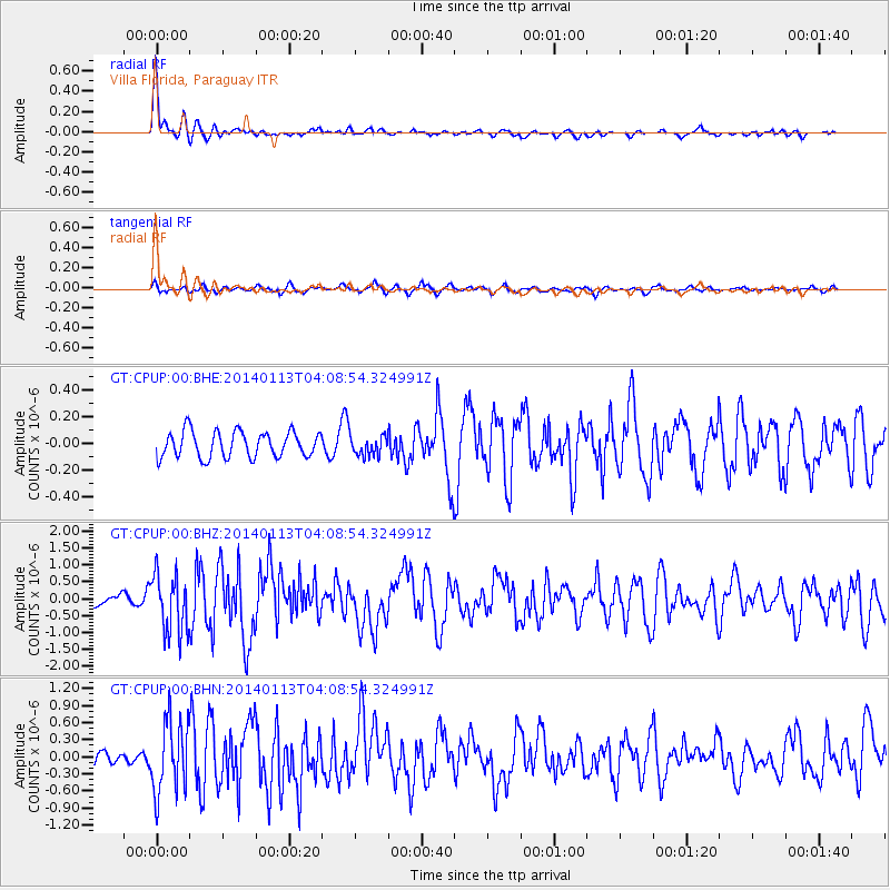
Signal To Noise
| Channel | StoN | STA | LTA |
| GT:CPUP:00:BHZ:20140113T04:08:54.324991Z | 5.713124 | 8.760753E-7 | 1.5334437E-7 |
| GT:CPUP:00:BHN:20140113T04:08:54.324991Z | 4.3451996 | 6.330951E-7 | 1.4569989E-7 |
| GT:CPUP:00:BHE:20140113T04:08:54.324991Z | 0.76432514 | 7.4453105E-8 | 9.741025E-8 |
| Arrivals |
| Ps | 1.2 SECOND |
| PpPs | 4.3 SECOND |
| PsPs/PpSs | 5.6 SECOND |


