You are here: Home > Network List > G - GEOSCOPE Stations List
> Station FOMA Nahampoana reservation, Fort Dauphin, Madagascar > Earthquake Result Viewer
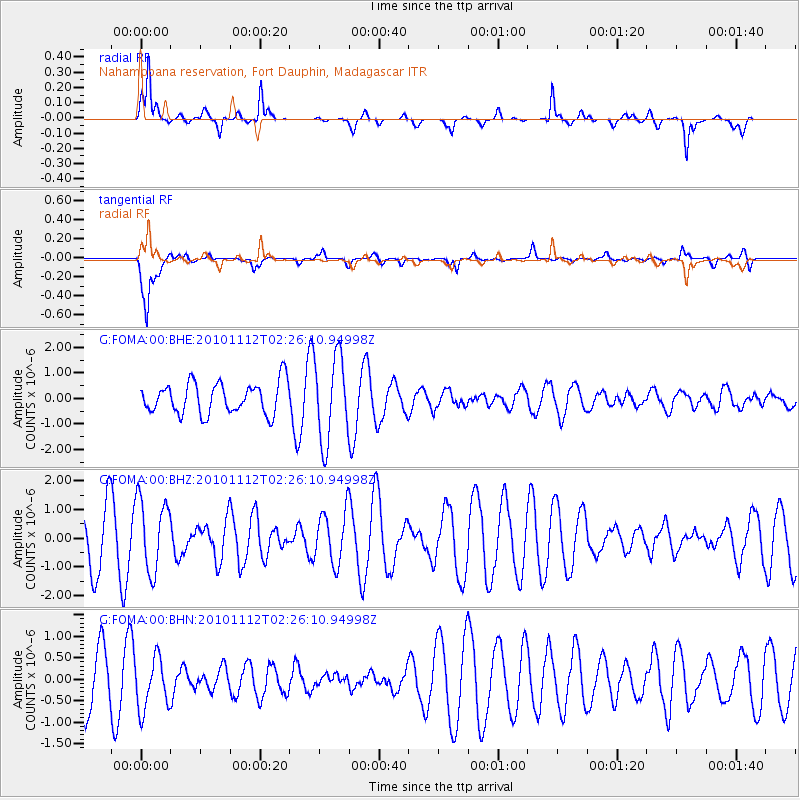
FOMA Nahampoana reservation, Fort Dauphin, Madagascar - Earthquake Result Viewer
*The percent match for this event was below the threshold and hence no stack was calculated.
| Earthquake location: |
Banda Sea |
| Earthquake latitude/longitude: |
-6.6/130.0 |
| Earthquake time(UTC): |
2010/11/12 (316) 02:14:46 GMT |
| Earthquake Depth: |
169 km |
| Earthquake Magnitude: |
5.7 MB, 5.5 MW, 5.5 MW |
| Earthquake Catalog/Contributor: |
WHDF/NEIC |
|
| Network: |
G GEOSCOPE |
| Station: |
FOMA Nahampoana reservation, Fort Dauphin, Madagascar |
| Lat/Lon: |
24.98 S/46.98 E |
| Elevation: |
26 m |
|
| Distance: |
81.0 deg |
| Az: |
245.807 deg |
| Baz: |
93.044 deg |
| Ray Param: |
$rayparam |
*The percent match for this event was below the threshold and hence was not used in the summary stack. |
|
| Radial Match: |
78.17364 % |
| Radial Bump: |
300 |
| Transverse Match: |
87.20666 % |
| Transverse Bump: |
400 |
| SOD ConfigId: |
346175 |
| Insert Time: |
2011-05-25 02:42:31.659 +0000 |
| GWidth: |
2.5 |
| Max Bumps: |
400 |
| Tol: |
0.001 |
|
Signal To Noise
| Channel | StoN | STA | LTA |
| G:FOMA:00:BHZ:20101112T02:26:10.94998Z | 1.0776201 | 1.2621798E-6 | 1.1712659E-6 |
| G:FOMA:00:BHN:20101112T02:26:10.94998Z | 0.816251 | 6.117678E-7 | 7.494849E-7 |
| G:FOMA:00:BHE:20101112T02:26:10.94998Z | 2.7485332 | 1.6793902E-6 | 6.110132E-7 |
| Arrivals |
| Ps | |
| PpPs | |
| PsPs/PpSs | |


