You are here: Home > Network List > CI - Caltech Regional Seismic Network Stations List
> Station LRL Laurel Mtn Radio Fac, Ridgecrest, CA, USA > Earthquake Result Viewer
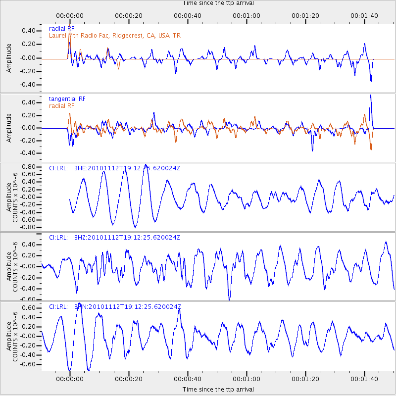
LRL Laurel Mtn Radio Fac, Ridgecrest, CA, USA - Earthquake Result Viewer
*The percent match for this event was below the threshold and hence no stack was calculated.
| Earthquake location: |
Southeast Of Easter Island |
| Earthquake latitude/longitude: |
-36.0/-102.2 |
| Earthquake time(UTC): |
2010/11/12 (316) 19:01:29 GMT |
| Earthquake Depth: |
10 km |
| Earthquake Magnitude: |
5.8 MW, 5.3 MS, 5.4 MB, 5.8 MW |
| Earthquake Catalog/Contributor: |
WHDF/NEIC |
|
| Network: |
CI Caltech Regional Seismic Network |
| Station: |
LRL Laurel Mtn Radio Fac, Ridgecrest, CA, USA |
| Lat/Lon: |
35.48 N/117.68 W |
| Elevation: |
1340 m |
|
| Distance: |
72.5 deg |
| Az: |
346.805 deg |
| Baz: |
166.885 deg |
| Ray Param: |
$rayparam |
*The percent match for this event was below the threshold and hence was not used in the summary stack. |
|
| Radial Match: |
47.2677 % |
| Radial Bump: |
362 |
| Transverse Match: |
51.402096 % |
| Transverse Bump: |
283 |
| SOD ConfigId: |
346175 |
| Insert Time: |
2011-05-25 02:52:58.468 +0000 |
| GWidth: |
2.5 |
| Max Bumps: |
400 |
| Tol: |
0.001 |
|
Signal To Noise
| Channel | StoN | STA | LTA |
| CI:LRL: :BHZ:20101112T19:12:25.620024Z | 0.98055404 | 1.9735431E-7 | 2.0126816E-7 |
| CI:LRL: :BHN:20101112T19:12:25.620024Z | 3.147774 | 5.329722E-7 | 1.6931718E-7 |
| CI:LRL: :BHE:20101112T19:12:25.620024Z | 0.8207341 | 3.5610705E-7 | 4.338885E-7 |
| Arrivals |
| Ps | |
| PpPs | |
| PsPs/PpSs | |


