You are here: Home > Network List > TA - USArray Transportable Network (new EarthScope stations) Stations List
> Station N23A Red Feather Lakes, CO, USA > Earthquake Result Viewer
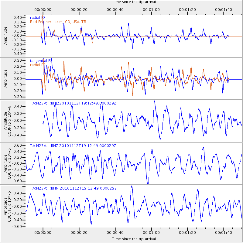
N23A Red Feather Lakes, CO, USA - Earthquake Result Viewer
*The percent match for this event was below the threshold and hence no stack was calculated.
| Earthquake location: |
Southeast Of Easter Island |
| Earthquake latitude/longitude: |
-36.0/-102.2 |
| Earthquake time(UTC): |
2010/11/12 (316) 19:01:29 GMT |
| Earthquake Depth: |
10 km |
| Earthquake Magnitude: |
5.8 MW, 5.3 MS, 5.4 MB, 5.8 MW |
| Earthquake Catalog/Contributor: |
WHDF/NEIC |
|
| Network: |
TA USArray Transportable Network (new EarthScope stations) |
| Station: |
N23A Red Feather Lakes, CO, USA |
| Lat/Lon: |
40.89 N/105.94 W |
| Elevation: |
2458 m |
|
| Distance: |
76.6 deg |
| Az: |
357.09 deg |
| Baz: |
176.886 deg |
| Ray Param: |
$rayparam |
*The percent match for this event was below the threshold and hence was not used in the summary stack. |
|
| Radial Match: |
52.717472 % |
| Radial Bump: |
367 |
| Transverse Match: |
40.14861 % |
| Transverse Bump: |
400 |
| SOD ConfigId: |
346175 |
| Insert Time: |
2011-05-25 02:59:48.938 +0000 |
| GWidth: |
2.5 |
| Max Bumps: |
400 |
| Tol: |
0.001 |
|
Signal To Noise
| Channel | StoN | STA | LTA |
| TA:N23A: :BHZ:20101112T19:12:49.000029Z | 1.7035989 | 3.0550692E-7 | 1.7933031E-7 |
| TA:N23A: :BHN:20101112T19:12:49.000029Z | 1.0383354 | 1.9978549E-7 | 1.9240939E-7 |
| TA:N23A: :BHE:20101112T19:12:49.000029Z | 1.4494709 | 3.3453804E-7 | 2.3080011E-7 |
| Arrivals |
| Ps | |
| PpPs | |
| PsPs/PpSs | |


