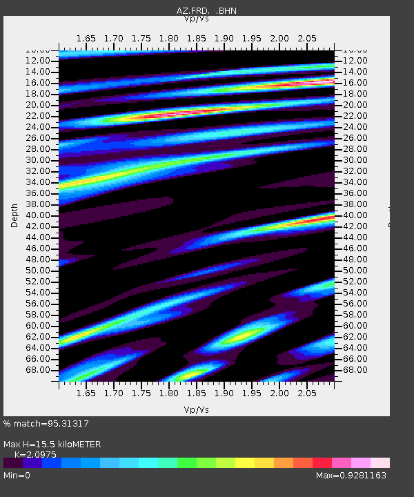
FRD AZ.FRD - Earthquake Result Viewer

Earthquake location: Southeast Of Loyalty Islands
Earthquake latitude/longitude: -22.3/170.9
Earthquake time(UTC): 1998/01/04 (004) 06:11:58 GMT
Earthquake Depth: 101 km
Earthquake Magnitude: 6.4 MB, 7.4 UNKNOWN, 7.3 ME
Earthquake Catalog/Contributor: WHDF/NEIC
Network: AZ ANZA Regional Network
Station: FRD AZ.FRD
Lat/Lon: 33.49 N/116.60 W
Elevation: 1164 m
Distance: 88.5 deg
Az: 52.86 deg
Baz: 242.062 deg
Ray Param: 0.042307157
Estimated Moho Depth: 15.5 km
Estimated Crust Vp/Vs: 2.10
Assumed Crust Vp: 6.264 km/s
Estimated Crust Vs: 2.986 km/s
Estimated Crust Poisson's Ratio: 0.35
Radial Match: 95.31317 %
Radial Bump: 400
Transverse Match: 90.854256 %
Transverse Bump: 400
SOD ConfigId: 9875
Insert Time: 2010-02-26 19:15:36.419 +0000
GWidth: 2.5
Max Bumps: 400
Tol: 0.001

Signal To Noise

ChannelStoNSTALTA
AZ:FRD: :BHN:19980104T06:24:08.998999Z0.55418091.8396167E-73.3195238E-7
AZ:FRD: :BHE:19980104T06:24:08.998999Z1.4213852.7128883E-71.9086231E-7
AZ:FRD: :BHZ:19980104T06:24:08.998999Z2.16646556.8431524E-73.158671E-7
Arrivals
Ps2.8 SECOND
PpPs7.5 SECOND
PsPs/PpSs10 SECOND