You are here: Home > Network List > TA - USArray Transportable Network (new EarthScope stations) Stations List
> Station N34A Lincoln, NE, USA > Earthquake Result Viewer
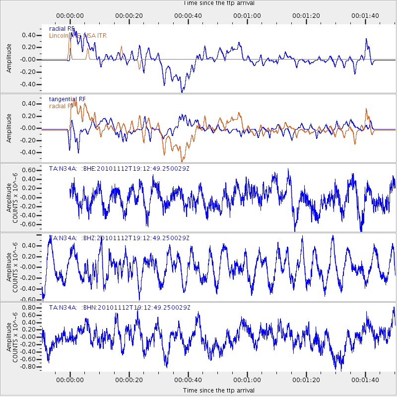
N34A Lincoln, NE, USA - Earthquake Result Viewer
*The percent match for this event was below the threshold and hence no stack was calculated.
| Earthquake location: |
Southeast Of Easter Island |
| Earthquake latitude/longitude: |
-36.0/-102.2 |
| Earthquake time(UTC): |
2010/11/12 (316) 19:01:29 GMT |
| Earthquake Depth: |
10 km |
| Earthquake Magnitude: |
5.8 MW, 5.3 MS, 5.4 MB, 5.8 MW |
| Earthquake Catalog/Contributor: |
WHDF/NEIC |
|
| Network: |
TA USArray Transportable Network (new EarthScope stations) |
| Station: |
N34A Lincoln, NE, USA |
| Lat/Lon: |
40.84 N/96.50 W |
| Elevation: |
401 m |
|
| Distance: |
76.6 deg |
| Az: |
4.45 deg |
| Baz: |
184.759 deg |
| Ray Param: |
$rayparam |
*The percent match for this event was below the threshold and hence was not used in the summary stack. |
|
| Radial Match: |
51.461124 % |
| Radial Bump: |
400 |
| Transverse Match: |
47.76997 % |
| Transverse Bump: |
400 |
| SOD ConfigId: |
346175 |
| Insert Time: |
2011-05-25 03:10:14.448 +0000 |
| GWidth: |
2.5 |
| Max Bumps: |
400 |
| Tol: |
0.001 |
|
Signal To Noise
| Channel | StoN | STA | LTA |
| TA:N34A: :BHZ:20101112T19:12:49.250029Z | 0.9548552 | 2.2106539E-7 | 2.3151719E-7 |
| TA:N34A: :BHN:20101112T19:12:49.250029Z | 1.2769969 | 2.7067182E-7 | 2.1195964E-7 |
| TA:N34A: :BHE:20101112T19:12:49.250029Z | 0.85234064 | 1.778123E-7 | 2.0861648E-7 |
| Arrivals |
| Ps | |
| PpPs | |
| PsPs/PpSs | |


