You are here: Home > Network List > TA - USArray Transportable Network (new EarthScope stations) Stations List
> Station V36A Jenks, OK, USA > Earthquake Result Viewer
V36A Jenks, OK, USA - Earthquake Result Viewer
*The percent match for this event was below the threshold and hence no stack was calculated.
| Earthquake location: |
Southeast Of Easter Island |
| Earthquake latitude/longitude: |
-36.0/-102.2 |
| Earthquake time(UTC): |
2010/11/12 (316) 19:01:29 GMT |
| Earthquake Depth: |
10 km |
| Earthquake Magnitude: |
5.8 MW, 5.3 MS, 5.4 MB, 5.8 MW |
| Earthquake Catalog/Contributor: |
WHDF/NEIC |
|
| Network: |
TA USArray Transportable Network (new EarthScope stations) |
| Station: |
V36A Jenks, OK, USA |
| Lat/Lon: |
35.79 N/95.94 W |
| Elevation: |
236 m |
|
| Distance: |
71.6 deg |
| Az: |
5.367 deg |
| Baz: |
185.355 deg |
| Ray Param: |
$rayparam |
*The percent match for this event was below the threshold and hence was not used in the summary stack. |
|
| Radial Match: |
51.955647 % |
| Radial Bump: |
400 |
| Transverse Match: |
52.141346 % |
| Transverse Bump: |
400 |
| SOD ConfigId: |
346175 |
| Insert Time: |
2011-05-25 03:11:43.018 +0000 |
| GWidth: |
2.5 |
| Max Bumps: |
400 |
| Tol: |
0.001 |
|
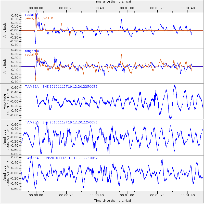
Signal To Noise
| Channel | StoN | STA | LTA |
| TA:V36A: :BHZ:20101112T19:12:20.225005Z | 2.6515286 | 4.929514E-7 | 1.8591214E-7 |
| TA:V36A: :BHN:20101112T19:12:20.225005Z | 1.365422 | 2.9917547E-7 | 2.1910841E-7 |
| TA:V36A: :BHE:20101112T19:12:20.225005Z | 0.9611785 | 1.3172524E-7 | 1.3704556E-7 |
| Arrivals |
| Ps | |
| PpPs | |
| PsPs/PpSs | |


