You are here: Home > Network List > TA - USArray Transportable Network (new EarthScope stations) Stations List
> Station V38A Canehill, AR, USA > Earthquake Result Viewer
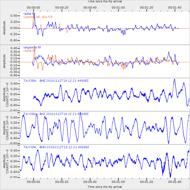
V38A Canehill, AR, USA - Earthquake Result Viewer
*The percent match for this event was below the threshold and hence no stack was calculated.
| Earthquake location: |
Southeast Of Easter Island |
| Earthquake latitude/longitude: |
-36.0/-102.2 |
| Earthquake time(UTC): |
2010/11/12 (316) 19:01:29 GMT |
| Earthquake Depth: |
10 km |
| Earthquake Magnitude: |
5.8 MW, 5.3 MS, 5.4 MB, 5.8 MW |
| Earthquake Catalog/Contributor: |
WHDF/NEIC |
|
| Network: |
TA USArray Transportable Network (new EarthScope stations) |
| Station: |
V38A Canehill, AR, USA |
| Lat/Lon: |
35.86 N/94.41 W |
| Elevation: |
372 m |
|
| Distance: |
71.8 deg |
| Az: |
6.665 deg |
| Baz: |
186.657 deg |
| Ray Param: |
$rayparam |
*The percent match for this event was below the threshold and hence was not used in the summary stack. |
|
| Radial Match: |
64.445885 % |
| Radial Bump: |
400 |
| Transverse Match: |
51.69911 % |
| Transverse Bump: |
400 |
| SOD ConfigId: |
346175 |
| Insert Time: |
2011-05-25 03:11:43.655 +0000 |
| GWidth: |
2.5 |
| Max Bumps: |
400 |
| Tol: |
0.001 |
|
Signal To Noise
| Channel | StoN | STA | LTA |
| TA:V38A: :BHZ:20101112T19:12:21.44998Z | 1.0779518 | 2.8278316E-7 | 2.6233377E-7 |
| TA:V38A: :BHN:20101112T19:12:21.44998Z | 1.545437 | 2.8579078E-7 | 1.8492555E-7 |
| TA:V38A: :BHE:20101112T19:12:21.44998Z | 1.2738191 | 1.8600173E-7 | 1.4601895E-7 |
| Arrivals |
| Ps | |
| PpPs | |
| PsPs/PpSs | |


