You are here: Home > Network List > TA - USArray Transportable Network (new EarthScope stations) Stations List
> Station K31A O'Neill, NE, USA > Earthquake Result Viewer
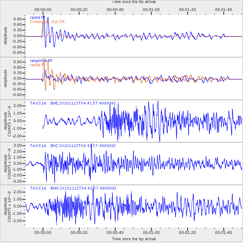
K31A O'Neill, NE, USA - Earthquake Result Viewer
*The percent match for this event was below the threshold and hence no stack was calculated.
| Earthquake location: |
Mona Passage |
| Earthquake latitude/longitude: |
17.9/-68.5 |
| Earthquake time(UTC): |
2010/11/13 (317) 04:35:39 GMT |
| Earthquake Depth: |
95 km |
| Earthquake Magnitude: |
5.6 MB, 5.4 MW, 5.6 MW |
| Earthquake Catalog/Contributor: |
WHDF/NEIC |
|
| Network: |
TA USArray Transportable Network (new EarthScope stations) |
| Station: |
K31A O'Neill, NE, USA |
| Lat/Lon: |
42.62 N/98.75 W |
| Elevation: |
580 m |
|
| Distance: |
35.6 deg |
| Az: |
320.337 deg |
| Baz: |
124.559 deg |
| Ray Param: |
$rayparam |
*The percent match for this event was below the threshold and hence was not used in the summary stack. |
|
| Radial Match: |
78.62399 % |
| Radial Bump: |
400 |
| Transverse Match: |
62.950123 % |
| Transverse Bump: |
400 |
| SOD ConfigId: |
346175 |
| Insert Time: |
2011-05-25 04:37:18.523 +0000 |
| GWidth: |
2.5 |
| Max Bumps: |
400 |
| Tol: |
0.001 |
|
Signal To Noise
| Channel | StoN | STA | LTA |
| TA:K31A: :BHZ:20101113T04:41:57.499999Z | 4.369087 | 1.0066971E-6 | 2.3041358E-7 |
| TA:K31A: :BHN:20101113T04:41:57.499999Z | 1.6756437 | 5.152429E-7 | 3.0748953E-7 |
| TA:K31A: :BHE:20101113T04:41:57.499999Z | 2.034531 | 7.254235E-7 | 3.565556E-7 |
| Arrivals |
| Ps | |
| PpPs | |
| PsPs/PpSs | |


