You are here: Home > Network List > TA - USArray Transportable Network (new EarthScope stations) Stations List
> Station D34A Park Rapids, MN, USA > Earthquake Result Viewer
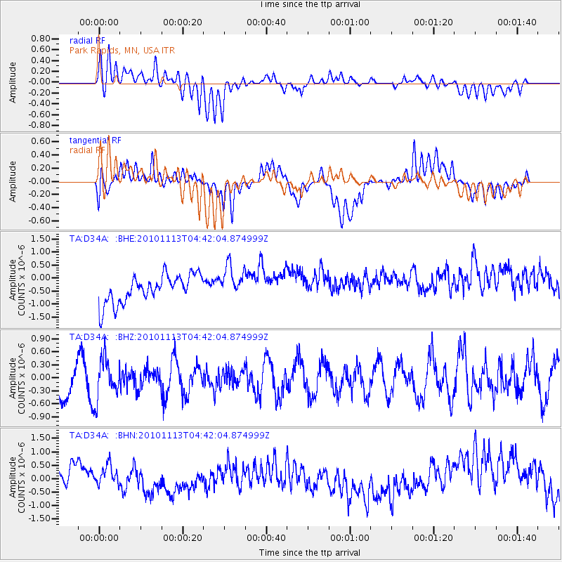
D34A Park Rapids, MN, USA - Earthquake Result Viewer
*The percent match for this event was below the threshold and hence no stack was calculated.
| Earthquake location: |
Mona Passage |
| Earthquake latitude/longitude: |
17.9/-68.5 |
| Earthquake time(UTC): |
2010/11/13 (317) 04:35:39 GMT |
| Earthquake Depth: |
95 km |
| Earthquake Magnitude: |
5.6 MB, 5.4 MW, 5.6 MW |
| Earthquake Catalog/Contributor: |
WHDF/NEIC |
|
| Network: |
TA USArray Transportable Network (new EarthScope stations) |
| Station: |
D34A Park Rapids, MN, USA |
| Lat/Lon: |
47.09 N/95.20 W |
| Elevation: |
476 m |
|
| Distance: |
36.5 deg |
| Az: |
328.939 deg |
| Baz: |
134.025 deg |
| Ray Param: |
$rayparam |
*The percent match for this event was below the threshold and hence was not used in the summary stack. |
|
| Radial Match: |
30.279663 % |
| Radial Bump: |
400 |
| Transverse Match: |
30.798065 % |
| Transverse Bump: |
400 |
| SOD ConfigId: |
346175 |
| Insert Time: |
2011-05-25 04:38:41.469 +0000 |
| GWidth: |
2.5 |
| Max Bumps: |
400 |
| Tol: |
0.001 |
|
Signal To Noise
| Channel | StoN | STA | LTA |
| TA:D34A: :BHZ:20101113T04:42:04.874999Z | 1.2071859 | 4.444314E-7 | 3.681549E-7 |
| TA:D34A: :BHN:20101113T04:42:04.874999Z | 0.99882436 | 5.460636E-7 | 5.467063E-7 |
| TA:D34A: :BHE:20101113T04:42:04.874999Z | 1.2102036 | 6.464294E-7 | 5.3414925E-7 |
| Arrivals |
| Ps | |
| PpPs | |
| PsPs/PpSs | |


