You are here: Home > Network List > AZ - ANZA Regional Network Stations List
> Station SOL AZ.SOL > Earthquake Result Viewer
SOL AZ.SOL - Earthquake Result Viewer
| Earthquake location: |
Santiago Del Estero Prov., Arg. |
| Earthquake latitude/longitude: |
-26.8/-63.1 |
| Earthquake time(UTC): |
2011/01/01 (001) 09:56:58 GMT |
| Earthquake Depth: |
577 km |
| Earthquake Magnitude: |
6.8 MB, 7.0 MW, 7.0 MW |
| Earthquake Catalog/Contributor: |
WHDF/NEIC |
|
| Network: |
AZ ANZA Regional Network |
| Station: |
SOL AZ.SOL |
| Lat/Lon: |
32.84 N/117.25 W |
| Elevation: |
245 m |
|
| Distance: |
78.5 deg |
| Az: |
315.898 deg |
| Baz: |
132.364 deg |
| Ray Param: |
0.04779746 |
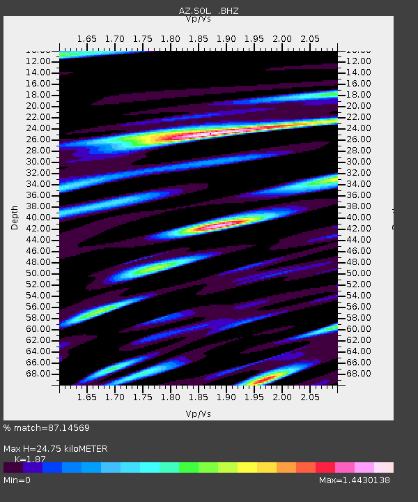
| Estimated Moho Depth: |
24.75 km |
| Estimated Crust Vp/Vs: |
1.87 |
| Assumed Crust Vp: |
6.264 km/s |
| Estimated Crust Vs: |
3.35 km/s |
| Estimated Crust Poisson's Ratio: |
0.30 |
|
| Radial Match: |
87.14569 % |
| Radial Bump: |
400 |
| Transverse Match: |
88.21479 % |
| Transverse Bump: |
400 |
| SOD ConfigId: |
346946 |
| Insert Time: |
2011-07-04 06:43:41.964 +0000 |
| GWidth: |
2.5 |
| Max Bumps: |
400 |
| Tol: |
0.001 |
|

Signal To Noise
| Channel | StoN | STA | LTA |
| AZ:SOL: :BHZ:20110101T10:07:29.299993Z | 28.732292 | 7.0950086E-6 | 2.46935E-7 |
| AZ:SOL: :BHN:20110101T10:07:29.299993Z | 3.3646739 | 1.7571522E-6 | 5.222355E-7 |
| AZ:SOL: :BHE:20110101T10:07:29.299993Z | 4.324205 | 3.0681338E-6 | 7.095255E-7 |
| Arrivals |
| Ps | 3.5 SECOND |
| PpPs | 11 SECOND |
| PsPs/PpSs | 15 SECOND |


