You are here: Home > Network List > GT - Global Telemetered Seismograph Network (USAF/USGS) Stations List
> Station DBIC Dimbokro, Cote d'Ivoire > Earthquake Result Viewer
DBIC Dimbokro, Cote d'Ivoire - Earthquake Result Viewer
| Earthquake location: |
Santiago Del Estero Prov., Arg. |
| Earthquake latitude/longitude: |
-26.8/-63.1 |
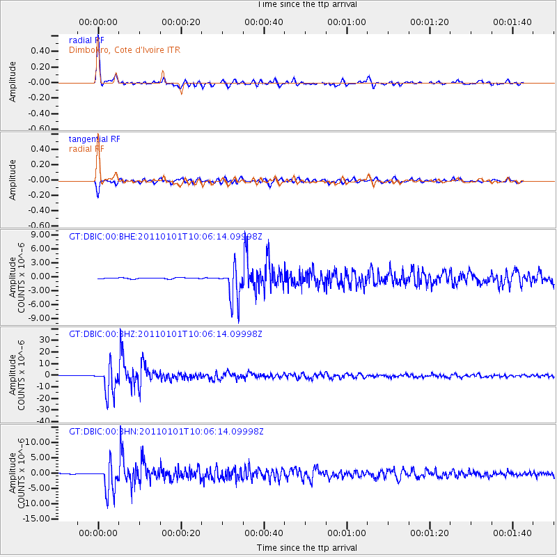
| Earthquake time(UTC): |
2011/01/01 (001) 09:56:58 GMT |
| Earthquake Depth: |
577 km |
| Earthquake Magnitude: |
6.8 MB, 7.0 MW, 7.0 MW |
| Earthquake Catalog/Contributor: |
WHDF/NEIC |
|
| Network: |
GT Global Telemetered Seismograph Network (USAF/USGS) |
| Station: |
DBIC Dimbokro, Cote d'Ivoire |
| Lat/Lon: |
6.67 N/4.86 W |
| Elevation: |
125 m |
|
| Distance: |
65.5 deg |
| Az: |
68.234 deg |
| Baz: |
236.682 deg |
| Ray Param: |
0.056125782 |
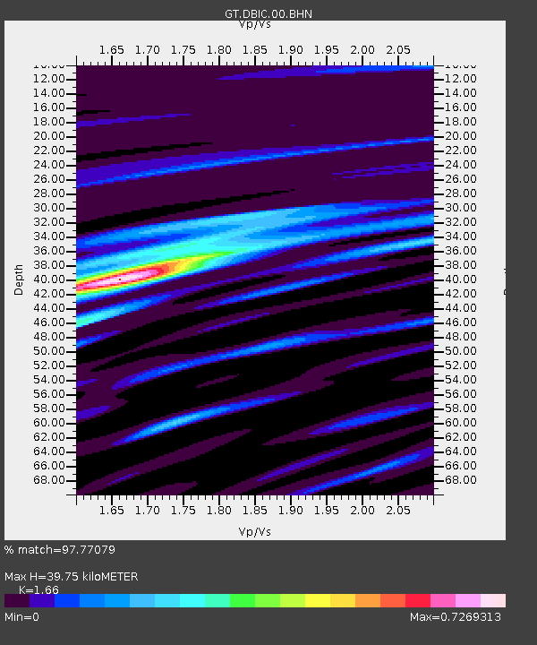
| Estimated Moho Depth: |
39.75 km |
| Estimated Crust Vp/Vs: |
1.66 |
| Assumed Crust Vp: |
6.419 km/s |
| Estimated Crust Vs: |
3.867 km/s |
| Estimated Crust Poisson's Ratio: |
0.22 |
|
| Radial Match: |
97.77079 % |
| Radial Bump: |
312 |
| Transverse Match: |
94.65094 % |
| Transverse Bump: |
400 |
| SOD ConfigId: |
346946 |
| Insert Time: |
2011-07-04 06:49:14.748 +0000 |
| GWidth: |
2.5 |
| Max Bumps: |
400 |
| Tol: |
0.001 |
|
Signal To Noise
| Channel | StoN | STA | LTA |
| GT:DBIC:00:BHZ:20110101T10:06:14.09998Z | 94.97765 | 1.2120118E-5 | 1.2761022E-7 |
| GT:DBIC:00:BHN:20110101T10:06:14.09998Z | 41.681114 | 4.628905E-6 | 1.1105522E-7 |
| GT:DBIC:00:BHE:20110101T10:06:14.09998Z | 32.21797 | 3.659789E-6 | 1.13594645E-7 |
| Arrivals |
| Ps | 4.3 SECOND |
| PpPs | 16 SECOND |
| PsPs/PpSs | 20 SECOND |


