You are here: Home > Network List > IW - Intermountain West Stations List
> Station DLMT Dillon, Montana, USA > Earthquake Result Viewer
DLMT Dillon, Montana, USA - Earthquake Result Viewer
| Earthquake location: |
Santiago Del Estero Prov., Arg. |
| Earthquake latitude/longitude: |
-26.8/-63.1 |
| Earthquake time(UTC): |
2011/01/01 (001) 09:56:58 GMT |
| Earthquake Depth: |
577 km |
| Earthquake Magnitude: |
6.8 MB, 7.0 MW, 7.0 MW |
| Earthquake Catalog/Contributor: |
WHDF/NEIC |
|
| Network: |
IW Intermountain West |
| Station: |
DLMT Dillon, Montana, USA |
| Lat/Lon: |
45.36 N/112.60 W |
| Elevation: |
1569 m |
|
| Distance: |
84.8 deg |
| Az: |
327.45 deg |
| Baz: |
136.993 deg |
| Ray Param: |
0.043577593 |
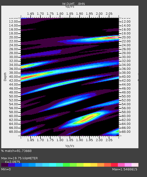
| Estimated Moho Depth: |
19.75 km |
| Estimated Crust Vp/Vs: |
2.10 |
| Assumed Crust Vp: |
6.577 km/s |
| Estimated Crust Vs: |
3.136 km/s |
| Estimated Crust Poisson's Ratio: |
0.35 |
|
| Radial Match: |
91.73668 % |
| Radial Bump: |
397 |
| Transverse Match: |
85.94656 % |
| Transverse Bump: |
400 |
| SOD ConfigId: |
346946 |
| Insert Time: |
2011-07-04 06:53:28.758 +0000 |
| GWidth: |
2.5 |
| Max Bumps: |
400 |
| Tol: |
0.001 |
|

Signal To Noise
| Channel | StoN | STA | LTA |
| IW:DLMT: :BHZ:20110101T10:08:00.864995Z | 41.054497 | 5.8032515E-6 | 1.4135483E-7 |
| IW:DLMT: :BHN:20110101T10:08:00.864995Z | 4.522922 | 1.4173679E-6 | 3.1337441E-7 |
| IW:DLMT: :BHE:20110101T10:08:00.864995Z | 3.1575568 | 1.7340604E-6 | 5.491779E-7 |
| Arrivals |
| Ps | 3.4 SECOND |
| PpPs | 9.1 SECOND |
| PsPs/PpSs | 12 SECOND |


