You are here: Home > Network List > NE - New England Seismic Network Stations List
> Station QUA2 Belchertown, MA > Earthquake Result Viewer
QUA2 Belchertown, MA - Earthquake Result Viewer
| Earthquake location: |
Santiago Del Estero Prov., Arg. |
| Earthquake latitude/longitude: |
-26.8/-63.1 |
| Earthquake time(UTC): |
2011/01/01 (001) 09:56:58 GMT |
| Earthquake Depth: |
577 km |
| Earthquake Magnitude: |
6.8 MB, 7.0 MW, 7.0 MW |
| Earthquake Catalog/Contributor: |
WHDF/NEIC |
|
| Network: |
NE New England Seismic Network |
| Station: |
QUA2 Belchertown, MA |
| Lat/Lon: |
42.28 N/72.35 W |
| Elevation: |
175 m |
|
| Distance: |
69.3 deg |
| Az: |
352.698 deg |
| Baz: |
171.196 deg |
| Ray Param: |
0.053747427 |
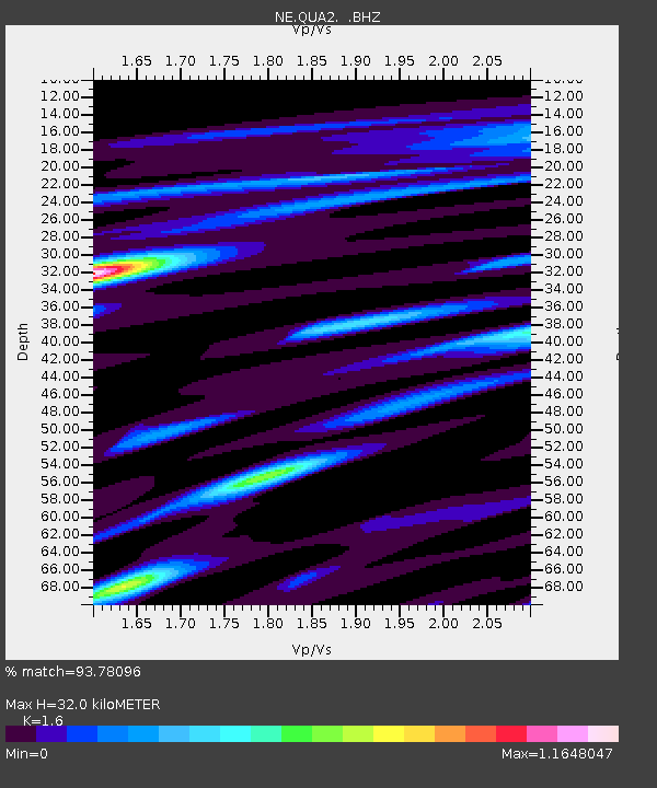
| Estimated Moho Depth: |
32.0 km |
| Estimated Crust Vp/Vs: |
1.60 |
| Assumed Crust Vp: |
6.419 km/s |
| Estimated Crust Vs: |
4.012 km/s |
| Estimated Crust Poisson's Ratio: |
0.18 |
|
| Radial Match: |
93.78096 % |
| Radial Bump: |
386 |
| Transverse Match: |
86.92179 % |
| Transverse Bump: |
400 |
| SOD ConfigId: |
346946 |
| Insert Time: |
2011-07-04 06:58:24.335 +0000 |
| GWidth: |
2.5 |
| Max Bumps: |
400 |
| Tol: |
0.001 |
|

Signal To Noise
| Channel | StoN | STA | LTA |
| NE:QUA2: :BHZ:20110101T10:06:37.145024Z | 21.347847 | 1.1415535E-5 | 5.347394E-7 |
| NE:QUA2: :BHN:20110101T10:06:37.145024Z | 12.919784 | 5.5592236E-6 | 4.3028768E-7 |
| NE:QUA2: :BHE:20110101T10:06:37.145024Z | 2.0562959 | 8.7684265E-7 | 4.264185E-7 |
| Arrivals |
| Ps | 3.1 SECOND |
| PpPs | 12 SECOND |
| PsPs/PpSs | 16 SECOND |


