You are here: Home > Network List > NE - New England Seismic Network Stations List
> Station PQI Presque Isle, ME > Earthquake Result Viewer
PQI Presque Isle, ME - Earthquake Result Viewer
| Earthquake location: |
Santiago Del Estero Prov., Arg. |
| Earthquake latitude/longitude: |
-26.8/-63.1 |
| Earthquake time(UTC): |
2011/01/01 (001) 09:56:58 GMT |
| Earthquake Depth: |
577 km |
| Earthquake Magnitude: |
6.8 MB, 7.0 MW, 7.0 MW |
| Earthquake Catalog/Contributor: |
WHDF/NEIC |
|
| Network: |
NE New England Seismic Network |
| Station: |
PQI Presque Isle, ME |
| Lat/Lon: |
46.67 N/68.01 W |
| Elevation: |
175 m |
|
| Distance: |
73.3 deg |
| Az: |
356.495 deg |
| Baz: |
175.449 deg |
| Ray Param: |
0.051210657 |
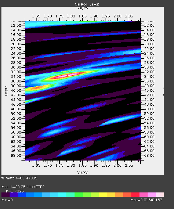
| Estimated Moho Depth: |
33.25 km |
| Estimated Crust Vp/Vs: |
1.78 |
| Assumed Crust Vp: |
6.419 km/s |
| Estimated Crust Vs: |
3.601 km/s |
| Estimated Crust Poisson's Ratio: |
0.27 |
|
| Radial Match: |
85.47035 % |
| Radial Bump: |
338 |
| Transverse Match: |
88.569534 % |
| Transverse Bump: |
400 |
| SOD ConfigId: |
346946 |
| Insert Time: |
2011-07-04 06:58:55.248 +0000 |
| GWidth: |
2.5 |
| Max Bumps: |
400 |
| Tol: |
0.001 |
|
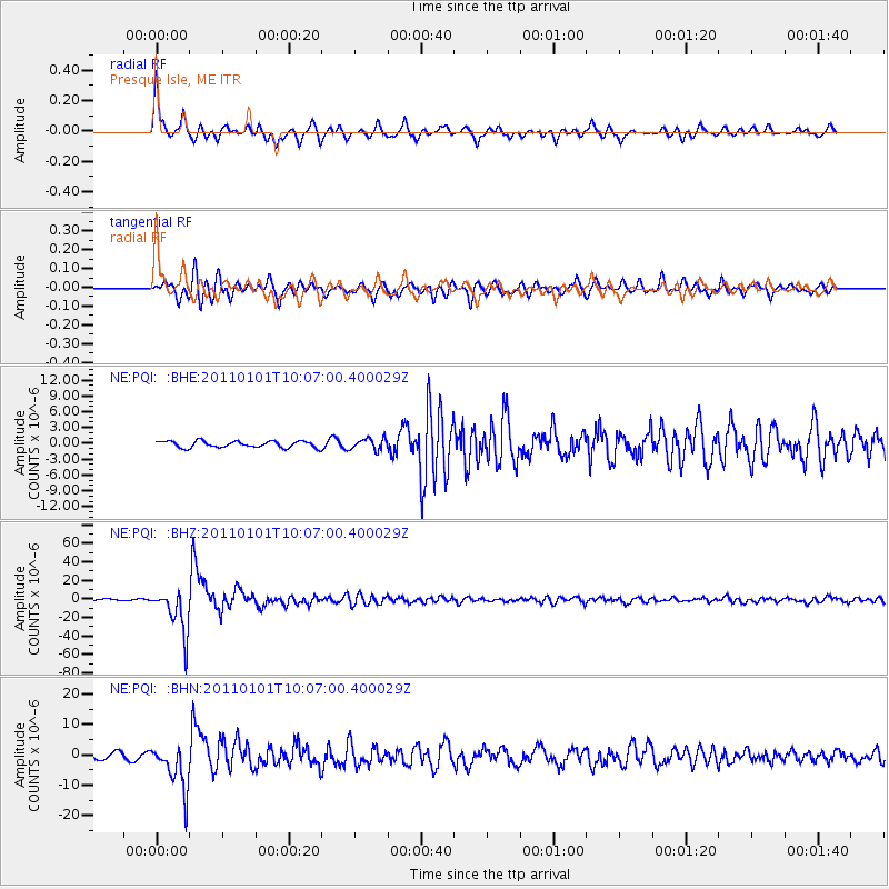
Signal To Noise
| Channel | StoN | STA | LTA |
| NE:PQI: :BHZ:20110101T10:07:00.400029Z | 25.136675 | 2.3696104E-5 | 9.4269046E-7 |
| NE:PQI: :BHN:20110101T10:07:00.400029Z | 9.003327 | 7.5061726E-6 | 8.3371094E-7 |
| NE:PQI: :BHE:20110101T10:07:00.400029Z | 1.7934592 | 1.0837639E-6 | 6.042869E-7 |
| Arrivals |
| Ps | 4.2 SECOND |
| PpPs | 14 SECOND |
| PsPs/PpSs | 18 SECOND |


