You are here: Home > Network List > NE - New England Seismic Network Stations List
> Station EMMW Machias, ME > Earthquake Result Viewer
EMMW Machias, ME - Earthquake Result Viewer
| Earthquake location: |
Santiago Del Estero Prov., Arg. |
| Earthquake latitude/longitude: |
-26.8/-63.1 |
| Earthquake time(UTC): |
2011/01/01 (001) 09:56:58 GMT |
| Earthquake Depth: |
577 km |
| Earthquake Magnitude: |
6.8 MB, 7.0 MW, 7.0 MW |
| Earthquake Catalog/Contributor: |
WHDF/NEIC |
|
| Network: |
NE New England Seismic Network |
| Station: |
EMMW Machias, ME |
| Lat/Lon: |
44.71 N/67.46 W |
| Elevation: |
34 m |
|
| Distance: |
71.3 deg |
| Az: |
356.747 deg |
| Baz: |
175.922 deg |
| Ray Param: |
0.0524763 |
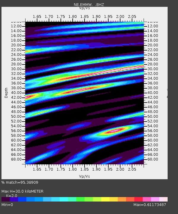
| Estimated Moho Depth: |
30.0 km |
| Estimated Crust Vp/Vs: |
2.00 |
| Assumed Crust Vp: |
6.419 km/s |
| Estimated Crust Vs: |
3.21 km/s |
| Estimated Crust Poisson's Ratio: |
0.33 |
|
| Radial Match: |
95.36909 % |
| Radial Bump: |
277 |
| Transverse Match: |
88.26704 % |
| Transverse Bump: |
333 |
| SOD ConfigId: |
346946 |
| Insert Time: |
2011-07-04 06:59:26.813 +0000 |
| GWidth: |
2.5 |
| Max Bumps: |
400 |
| Tol: |
0.001 |
|

Signal To Noise
| Channel | StoN | STA | LTA |
| NE:EMMW: :BHZ:20110101T10:06:49.010015Z | 16.478365 | 2.0781794E-5 | 1.2611563E-6 |
| NE:EMMW: :BHN:20110101T10:06:49.010015Z | 13.829397 | 7.5997064E-6 | 5.4953273E-7 |
| NE:EMMW: :BHE:20110101T10:06:49.010015Z | 1.8005074 | 1.1592712E-6 | 6.43858E-7 |
| Arrivals |
| Ps | 4.8 SECOND |
| PpPs | 14 SECOND |
| PsPs/PpSs | 18 SECOND |


