You are here: Home > Network List > NE - New England Seismic Network Stations List
> Station BRYW Smithfield, RI > Earthquake Result Viewer
BRYW Smithfield, RI - Earthquake Result Viewer
| Earthquake location: |
Santiago Del Estero Prov., Arg. |
| Earthquake latitude/longitude: |
-26.8/-63.1 |
| Earthquake time(UTC): |
2011/01/01 (001) 09:56:58 GMT |
| Earthquake Depth: |
577 km |
| Earthquake Magnitude: |
6.8 MB, 7.0 MW, 7.0 MW |
| Earthquake Catalog/Contributor: |
WHDF/NEIC |
|
| Network: |
NE New England Seismic Network |
| Station: |
BRYW Smithfield, RI |
| Lat/Lon: |
41.92 N/71.54 W |
| Elevation: |
107 m |
|
| Distance: |
68.8 deg |
| Az: |
353.284 deg |
| Baz: |
171.949 deg |
| Ray Param: |
0.054031413 |
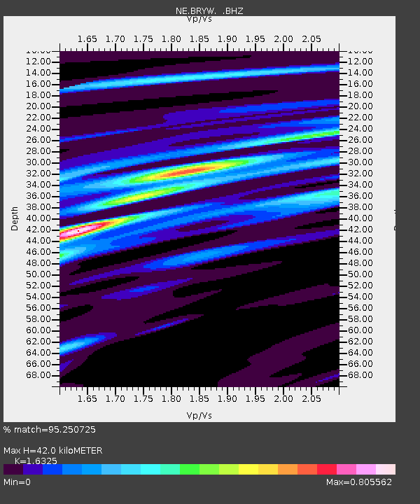
| Estimated Moho Depth: |
42.0 km |
| Estimated Crust Vp/Vs: |
1.63 |
| Assumed Crust Vp: |
6.472 km/s |
| Estimated Crust Vs: |
3.964 km/s |
| Estimated Crust Poisson's Ratio: |
0.20 |
|
| Radial Match: |
95.250725 % |
| Radial Bump: |
266 |
| Transverse Match: |
70.80428 % |
| Transverse Bump: |
400 |
| SOD ConfigId: |
346946 |
| Insert Time: |
2011-07-04 06:59:53.088 +0000 |
| GWidth: |
2.5 |
| Max Bumps: |
400 |
| Tol: |
0.001 |
|

Signal To Noise
| Channel | StoN | STA | LTA |
| NE:BRYW: :BHZ:20110101T10:06:34.464971Z | 60.30277 | 2.8113769E-5 | 4.6621025E-7 |
| NE:BRYW: :BHN:20110101T10:06:34.464971Z | 20.352007 | 1.3557168E-5 | 6.661342E-7 |
| NE:BRYW: :BHE:20110101T10:06:34.464971Z | 1.4915735 | 1.282488E-6 | 8.598222E-7 |
| Arrivals |
| Ps | 4.3 SECOND |
| PpPs | 16 SECOND |
| PsPs/PpSs | 21 SECOND |


