You are here: Home > Network List > TA - USArray Transportable Network (new EarthScope stations) Stations List
> Station R56A Bull Pasture Mountain, McDowell, VA, USA > Earthquake Result Viewer
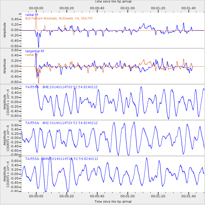
R56A Bull Pasture Mountain, McDowell, VA, USA - Earthquake Result Viewer
*The percent match for this event was below the threshold and hence no stack was calculated.
| Earthquake location: |
East Of Severnaya Zemlya |
| Earthquake latitude/longitude: |
78.8/126.0 |
| Earthquake time(UTC): |
2014/01/14 (014) 03:43:05 GMT |
| Earthquake Depth: |
10 km |
| Earthquake Magnitude: |
4.1 mb |
| Earthquake Catalog/Contributor: |
ISC/ISC |
|
| Network: |
TA USArray Transportable Network (new EarthScope stations) |
| Station: |
R56A Bull Pasture Mountain, McDowell, VA, USA |
| Lat/Lon: |
38.41 N/79.40 W |
| Elevation: |
902 m |
|
| Distance: |
62.1 deg |
| Az: |
22.387 deg |
| Baz: |
354.568 deg |
| Ray Param: |
$rayparam |
*The percent match for this event was below the threshold and hence was not used in the summary stack. |
|
| Radial Match: |
63.74672 % |
| Radial Bump: |
400 |
| Transverse Match: |
68.89874 % |
| Transverse Bump: |
400 |
| SOD ConfigId: |
3390531 |
| Insert Time: |
2019-04-09 23:51:49.652 +0000 |
| GWidth: |
2.5 |
| Max Bumps: |
400 |
| Tol: |
0.001 |
|
Signal To Noise
| Channel | StoN | STA | LTA |
| TA:R56A: :BHZ:20140114T03:52:54.824021Z | 1.6781142 | 3.909892E-7 | 2.3299319E-7 |
| TA:R56A: :BHN:20140114T03:52:54.824021Z | 2.715877 | 4.6721073E-7 | 1.7202942E-7 |
| TA:R56A: :BHE:20140114T03:52:54.824021Z | 0.42034277 | 1.3979053E-7 | 3.325632E-7 |
| Arrivals |
| Ps | |
| PpPs | |
| PsPs/PpSs | |


