You are here: Home > Network List > TA - USArray Transportable Network (new EarthScope stations) Stations List
> Station Q24A Divide, CO, USA > Earthquake Result Viewer
Q24A Divide, CO, USA - Earthquake Result Viewer

| Earthquake location: |
Santiago Del Estero Prov., Arg. |
| Earthquake latitude/longitude: |
-26.8/-63.1 |
| Earthquake time(UTC): |
2011/01/01 (001) 09:56:58 GMT |
| Earthquake Depth: |
577 km |
| Earthquake Magnitude: |
6.8 MB, 7.0 MW, 7.0 MW |
| Earthquake Catalog/Contributor: |
WHDF/NEIC |
|
| Network: |
TA USArray Transportable Network (new EarthScope stations) |
| Station: |
Q24A Divide, CO, USA |
| Lat/Lon: |
38.96 N/105.15 W |
| Elevation: |
2775 m |
|
| Distance: |
76.3 deg |
| Az: |
327.516 deg |
| Baz: |
141.996 deg |
| Ray Param: |
0.049248762 |
| Estimated Moho Depth: |
39.25 km |
| Estimated Crust Vp/Vs: |
2.05 |
| Assumed Crust Vp: |
6.159 km/s |
| Estimated Crust Vs: |
3.001 km/s |
| Estimated Crust Poisson's Ratio: |
0.34 |
|
| Radial Match: |
95.07982 % |
| Radial Bump: |
280 |
| Transverse Match: |
87.26126 % |
| Transverse Bump: |
279 |
| SOD ConfigId: |
346946 |
| Insert Time: |
2011-07-04 07:05:33.515 +0000 |
| GWidth: |
2.5 |
| Max Bumps: |
400 |
| Tol: |
0.001 |
|
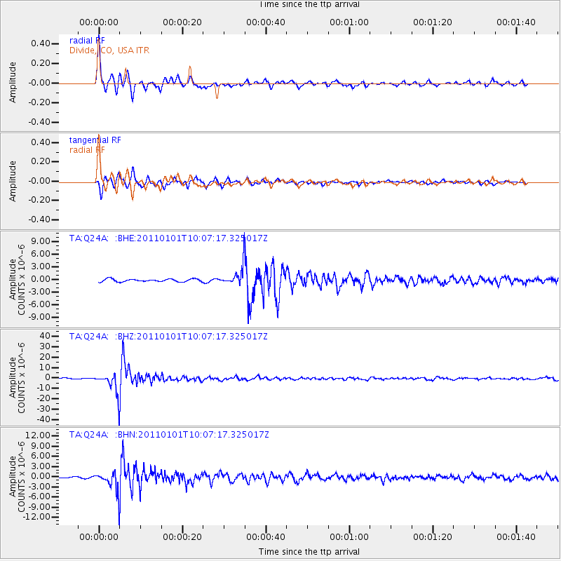
Signal To Noise
| Channel | StoN | STA | LTA |
| TA:Q24A: :BHZ:20110101T10:07:17.325017Z | 27.257355 | 1.0166709E-5 | 3.7298958E-7 |
| TA:Q24A: :BHN:20110101T10:07:17.325017Z | 18.880611 | 2.8549969E-6 | 1.5121314E-7 |
| TA:Q24A: :BHE:20110101T10:07:17.325017Z | 7.5621166 | 2.4187004E-6 | 3.1984436E-7 |
| Arrivals |
| Ps | 6.9 SECOND |
| PpPs | 19 SECOND |
| PsPs/PpSs | 26 SECOND |


