You are here: Home > Network List > TA - USArray Transportable Network (new EarthScope stations) Stations List
> Station MDND Maddock, ND, USA > Earthquake Result Viewer
MDND Maddock, ND, USA - Earthquake Result Viewer
| Earthquake location: |
Santiago Del Estero Prov., Arg. |
| Earthquake latitude/longitude: |
-26.8/-63.1 |
| Earthquake time(UTC): |
2011/01/01 (001) 09:56:58 GMT |
| Earthquake Depth: |
577 km |
| Earthquake Magnitude: |
6.8 MB, 7.0 MW, 7.0 MW |
| Earthquake Catalog/Contributor: |
WHDF/NEIC |
|
| Network: |
TA USArray Transportable Network (new EarthScope stations) |
| Station: |
MDND Maddock, ND, USA |
| Lat/Lon: |
47.85 N/99.60 W |
| Elevation: |
479 m |
|
| Distance: |
81.2 deg |
| Az: |
336.103 deg |
| Baz: |
147.485 deg |
| Ray Param: |
0.045992095 |
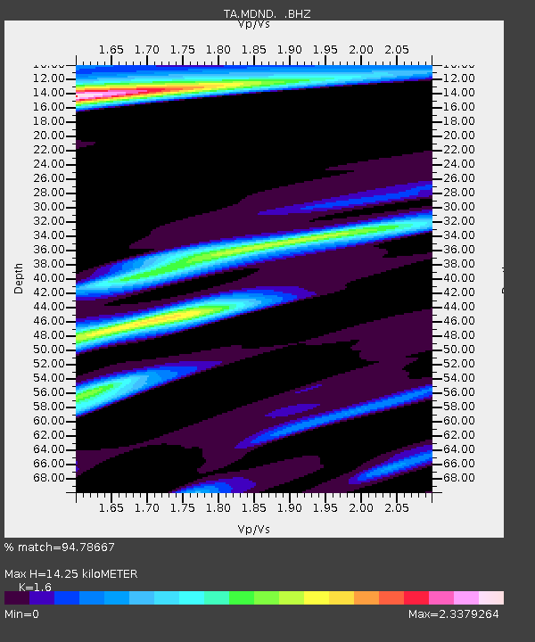
| Estimated Moho Depth: |
14.25 km |
| Estimated Crust Vp/Vs: |
1.60 |
| Assumed Crust Vp: |
6.53 km/s |
| Estimated Crust Vs: |
4.082 km/s |
| Estimated Crust Poisson's Ratio: |
0.18 |
|
| Radial Match: |
94.78667 % |
| Radial Bump: |
336 |
| Transverse Match: |
88.15881 % |
| Transverse Bump: |
385 |
| SOD ConfigId: |
346946 |
| Insert Time: |
2011-07-04 07:06:42.067 +0000 |
| GWidth: |
2.5 |
| Max Bumps: |
400 |
| Tol: |
0.001 |
|
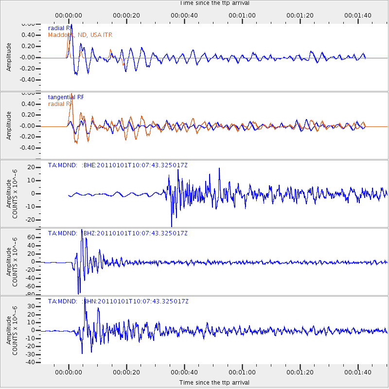
Signal To Noise
| Channel | StoN | STA | LTA |
| TA:MDND: :BHZ:20110101T10:07:43.325017Z | 136.00839 | 3.2182892E-5 | 2.3662432E-7 |
| TA:MDND: :BHN:20110101T10:07:43.325017Z | 5.3121023 | 6.707019E-6 | 1.2625923E-6 |
| TA:MDND: :BHE:20110101T10:07:43.325017Z | 4.297313 | 3.5330595E-6 | 8.221555E-7 |
| Arrivals |
| Ps | 1.3 SECOND |
| PpPs | 5.5 SECOND |
| PsPs/PpSs | 6.9 SECOND |


