You are here: Home > Network List > TA - USArray Transportable Network (new EarthScope stations) Stations List
> Station 231A Bronte, TX, USA > Earthquake Result Viewer
231A Bronte, TX, USA - Earthquake Result Viewer

| Earthquake location: |
Santiago Del Estero Prov., Arg. |
| Earthquake latitude/longitude: |
-26.8/-63.1 |
| Earthquake time(UTC): |
2011/01/01 (001) 09:56:58 GMT |
| Earthquake Depth: |
577 km |
| Earthquake Magnitude: |
6.8 MB, 7.0 MW, 7.0 MW |
| Earthquake Catalog/Contributor: |
WHDF/NEIC |
|
| Network: |
TA USArray Transportable Network (new EarthScope stations) |
| Station: |
231A Bronte, TX, USA |
| Lat/Lon: |
31.94 N/100.32 W |
| Elevation: |
574 m |
|
| Distance: |
68.3 deg |
| Az: |
326.433 deg |
| Baz: |
144.463 deg |
| Ray Param: |
0.05434339 |
| Estimated Moho Depth: |
40.0 km |
| Estimated Crust Vp/Vs: |
1.73 |
| Assumed Crust Vp: |
6.38 km/s |
| Estimated Crust Vs: |
3.683 km/s |
| Estimated Crust Poisson's Ratio: |
0.25 |
|
| Radial Match: |
92.932205 % |
| Radial Bump: |
299 |
| Transverse Match: |
87.43597 % |
| Transverse Bump: |
400 |
| SOD ConfigId: |
346946 |
| Insert Time: |
2011-07-04 07:10:04.864 +0000 |
| GWidth: |
2.5 |
| Max Bumps: |
400 |
| Tol: |
0.001 |
|
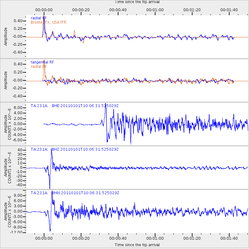
Signal To Noise
| Channel | StoN | STA | LTA |
| TA:231A: :BHZ:20110101T10:06:31.525029Z | 71.43955 | 1.7252007E-5 | 2.4149097E-7 |
| TA:231A: :BHN:20110101T10:06:31.525029Z | 28.846449 | 5.134648E-6 | 1.7799931E-7 |
| TA:231A: :BHE:20110101T10:06:31.525029Z | 18.996643 | 3.235702E-6 | 1.703302E-7 |
| Arrivals |
| Ps | 4.8 SECOND |
| PpPs | 17 SECOND |
| PsPs/PpSs | 21 SECOND |


