You are here: Home > Network List > TA - USArray Transportable Network (new EarthScope stations) Stations List
> Station 330A Mertzon, TX, USA > Earthquake Result Viewer
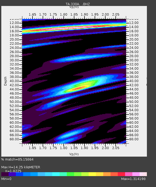
330A Mertzon, TX, USA - Earthquake Result Viewer
| Earthquake location: |
Santiago Del Estero Prov., Arg. |
| Earthquake latitude/longitude: |
-26.8/-63.1 |
| Earthquake time(UTC): |
2011/01/01 (001) 09:56:58 GMT |
| Earthquake Depth: |
577 km |
| Earthquake Magnitude: |
6.8 MB, 7.0 MW, 7.0 MW |
| Earthquake Catalog/Contributor: |
WHDF/NEIC |
|
| Network: |
TA USArray Transportable Network (new EarthScope stations) |
| Station: |
330A Mertzon, TX, USA |
| Lat/Lon: |
31.41 N/101.18 W |
| Elevation: |
742 m |
|
| Distance: |
68.3 deg |
| Az: |
325.462 deg |
| Baz: |
143.655 deg |
| Ray Param: |
0.05434157 |
| Estimated Moho Depth: |
14.25 km |
| Estimated Crust Vp/Vs: |
1.82 |
| Assumed Crust Vp: |
6.38 km/s |
| Estimated Crust Vs: |
3.501 km/s |
| Estimated Crust Poisson's Ratio: |
0.28 |
|
| Radial Match: |
85.15864 % |
| Radial Bump: |
353 |
| Transverse Match: |
75.84561 % |
| Transverse Bump: |
400 |
| SOD ConfigId: |
346946 |
| Insert Time: |
2011-07-04 07:10:36.050 +0000 |
| GWidth: |
2.5 |
| Max Bumps: |
400 |
| Tol: |
0.001 |
|

Signal To Noise
| Channel | StoN | STA | LTA |
| TA:330A: :BHZ:20110101T10:06:31.549993Z | 82.47638 | 1.5771884E-5 | 1.912291E-7 |
| TA:330A: :BHN:20110101T10:06:31.549993Z | 16.353214 | 3.9580623E-6 | 2.4203572E-7 |
| TA:330A: :BHE:20110101T10:06:31.549993Z | 6.958052 | 2.927127E-6 | 4.2068197E-7 |
| Arrivals |
| Ps | 1.9 SECOND |
| PpPs | 6.1 SECOND |
| PsPs/PpSs | 8.0 SECOND |


