You are here: Home > Network List > TA - USArray Transportable Network (new EarthScope stations) Stations List
> Station T31A Randall Ranch, Ashland, KS, USA > Earthquake Result Viewer
T31A Randall Ranch, Ashland, KS, USA - Earthquake Result Viewer

| Earthquake location: |
Santiago Del Estero Prov., Arg. |
| Earthquake latitude/longitude: |
-26.8/-63.1 |
| Earthquake time(UTC): |
2011/01/01 (001) 09:56:58 GMT |
| Earthquake Depth: |
577 km |
| Earthquake Magnitude: |
6.8 MB, 7.0 MW, 7.0 MW |
| Earthquake Catalog/Contributor: |
WHDF/NEIC |
|
| Network: |
TA USArray Transportable Network (new EarthScope stations) |
| Station: |
T31A Randall Ranch, Ashland, KS, USA |
| Lat/Lon: |
37.10 N/99.68 W |
| Elevation: |
564 m |
|
| Distance: |
72.3 deg |
| Az: |
330.011 deg |
| Baz: |
146.032 deg |
| Ray Param: |
0.051853932 |
| Estimated Moho Depth: |
44.5 km |
| Estimated Crust Vp/Vs: |
1.81 |
| Assumed Crust Vp: |
6.426 km/s |
| Estimated Crust Vs: |
3.545 km/s |
| Estimated Crust Poisson's Ratio: |
0.28 |
|
| Radial Match: |
95.692055 % |
| Radial Bump: |
307 |
| Transverse Match: |
82.03401 % |
| Transverse Bump: |
379 |
| SOD ConfigId: |
346946 |
| Insert Time: |
2011-07-04 07:13:13.064 +0000 |
| GWidth: |
2.5 |
| Max Bumps: |
400 |
| Tol: |
0.001 |
|
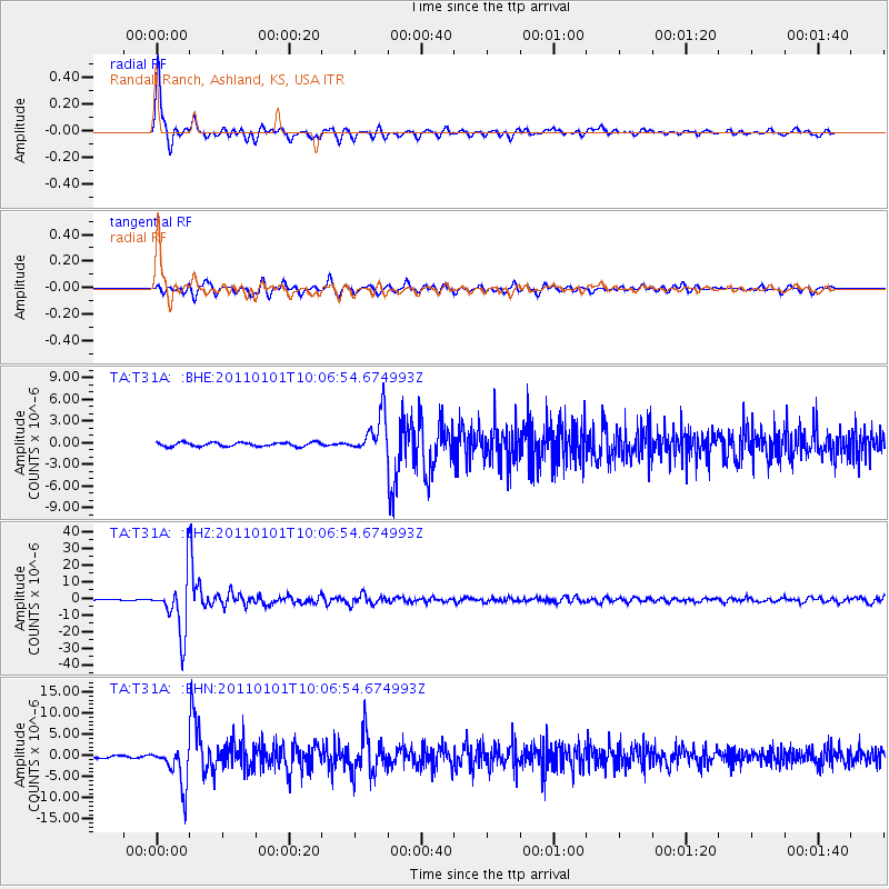
Signal To Noise
| Channel | StoN | STA | LTA |
| TA:T31A: :BHZ:20110101T10:06:54.674993Z | 69.88614 | 1.6334825E-5 | 2.3373484E-7 |
| TA:T31A: :BHN:20110101T10:06:54.674993Z | 13.078596 | 4.5649044E-6 | 3.4903627E-7 |
| TA:T31A: :BHE:20110101T10:06:54.674993Z | 9.994209 | 2.7005292E-6 | 2.702094E-7 |
| Arrivals |
| Ps | 5.8 SECOND |
| PpPs | 19 SECOND |
| PsPs/PpSs | 25 SECOND |


