You are here: Home > Network List > TA - USArray Transportable Network (new EarthScope stations) Stations List
> Station Q30A Quinter, KS, USA > Earthquake Result Viewer
Q30A Quinter, KS, USA - Earthquake Result Viewer
| Earthquake location: |
Santiago Del Estero Prov., Arg. |
| Earthquake latitude/longitude: |
-26.8/-63.1 |
| Earthquake time(UTC): |
2011/01/01 (001) 09:56:58 GMT |
| Earthquake Depth: |
577 km |
| Earthquake Magnitude: |
6.8 MB, 7.0 MW, 7.0 MW |
| Earthquake Catalog/Contributor: |
WHDF/NEIC |
|
| Network: |
TA USArray Transportable Network (new EarthScope stations) |
| Station: |
Q30A Quinter, KS, USA |
| Lat/Lon: |
38.98 N/100.22 W |
| Elevation: |
797 m |
|
| Distance: |
74.1 deg |
| Az: |
330.737 deg |
| Baz: |
145.908 deg |
| Ray Param: |
0.05070351 |
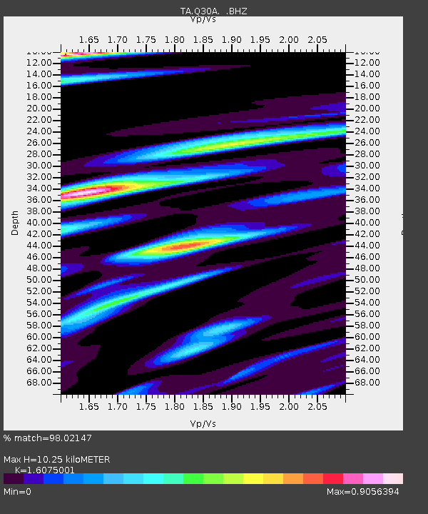
| Estimated Moho Depth: |
10.25 km |
| Estimated Crust Vp/Vs: |
1.61 |
| Assumed Crust Vp: |
6.483 km/s |
| Estimated Crust Vs: |
4.033 km/s |
| Estimated Crust Poisson's Ratio: |
0.18 |
|
| Radial Match: |
98.02147 % |
| Radial Bump: |
297 |
| Transverse Match: |
92.475815 % |
| Transverse Bump: |
350 |
| SOD ConfigId: |
346946 |
| Insert Time: |
2011-07-04 07:17:19.324 +0000 |
| GWidth: |
2.5 |
| Max Bumps: |
400 |
| Tol: |
0.001 |
|

Signal To Noise
| Channel | StoN | STA | LTA |
| TA:Q30A: :BHZ:20110101T10:07:04.875005Z | 117.27119 | 2.405882E-5 | 2.0515543E-7 |
| TA:Q30A: :BHN:20110101T10:07:04.875005Z | 11.053152 | 5.2366067E-6 | 4.7376594E-7 |
| TA:Q30A: :BHE:20110101T10:07:04.875005Z | 17.787334 | 5.28147E-6 | 2.9692305E-7 |
| Arrivals |
| Ps | 1.0 SECOND |
| PpPs | 4.0 SECOND |
| PsPs/PpSs | 5.0 SECOND |


