You are here: Home > Network List > TA - USArray Transportable Network (new EarthScope stations) Stations List
> Station N29A Votaw Ranch, Wellfleet, NE, USA > Earthquake Result Viewer
N29A Votaw Ranch, Wellfleet, NE, USA - Earthquake Result Viewer
| Earthquake location: |
Santiago Del Estero Prov., Arg. |
| Earthquake latitude/longitude: |
-26.8/-63.1 |
| Earthquake time(UTC): |
2011/01/01 (001) 09:56:58 GMT |
| Earthquake Depth: |
577 km |
| Earthquake Magnitude: |
6.8 MB, 7.0 MW, 7.0 MW |
| Earthquake Catalog/Contributor: |
WHDF/NEIC |
|
| Network: |
TA USArray Transportable Network (new EarthScope stations) |
| Station: |
N29A Votaw Ranch, Wellfleet, NE, USA |
| Lat/Lon: |
40.82 N/100.63 W |
| Elevation: |
897 m |
|
| Distance: |
75.7 deg |
| Az: |
331.538 deg |
| Baz: |
145.858 deg |
| Ray Param: |
0.04960581 |
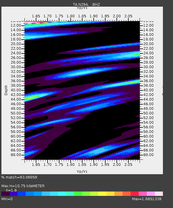
| Estimated Moho Depth: |
10.75 km |
| Estimated Crust Vp/Vs: |
1.60 |
| Assumed Crust Vp: |
6.483 km/s |
| Estimated Crust Vs: |
4.052 km/s |
| Estimated Crust Poisson's Ratio: |
0.18 |
|
| Radial Match: |
93.89859 % |
| Radial Bump: |
301 |
| Transverse Match: |
89.19989 % |
| Transverse Bump: |
312 |
| SOD ConfigId: |
346946 |
| Insert Time: |
2011-07-04 07:18:09.477 +0000 |
| GWidth: |
2.5 |
| Max Bumps: |
400 |
| Tol: |
0.001 |
|
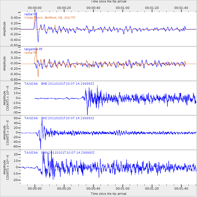
Signal To Noise
| Channel | StoN | STA | LTA |
| TA:N29A: :BHZ:20110101T10:07:14.299993Z | 62.841145 | 2.0039786E-5 | 3.1889596E-7 |
| TA:N29A: :BHN:20110101T10:07:14.299993Z | 6.2972517 | 3.653294E-6 | 5.8014103E-7 |
| TA:N29A: :BHE:20110101T10:07:14.299993Z | 7.78448 | 4.3981195E-6 | 5.649856E-7 |
| Arrivals |
| Ps | 1.0 SECOND |
| PpPs | 4.2 SECOND |
| PsPs/PpSs | 5.2 SECOND |


