You are here: Home > Network List > TA - USArray Transportable Network (new EarthScope stations) Stations List
> Station N28A Pribbeno Ranch, Imperial, NE, USA > Earthquake Result Viewer
N28A Pribbeno Ranch, Imperial, NE, USA - Earthquake Result Viewer
| Earthquake location: |
Santiago Del Estero Prov., Arg. |
| Earthquake latitude/longitude: |
-26.8/-63.1 |
| Earthquake time(UTC): |
2011/01/01 (001) 09:56:58 GMT |
| Earthquake Depth: |
577 km |
| Earthquake Magnitude: |
6.8 MB, 7.0 MW, 7.0 MW |
| Earthquake Catalog/Contributor: |
WHDF/NEIC |
|
| Network: |
TA USArray Transportable Network (new EarthScope stations) |
| Station: |
N28A Pribbeno Ranch, Imperial, NE, USA |
| Lat/Lon: |
40.69 N/101.54 W |
| Elevation: |
1009 m |
|
| Distance: |
76.0 deg |
| Az: |
330.871 deg |
| Baz: |
145.101 deg |
| Ray Param: |
0.049421232 |
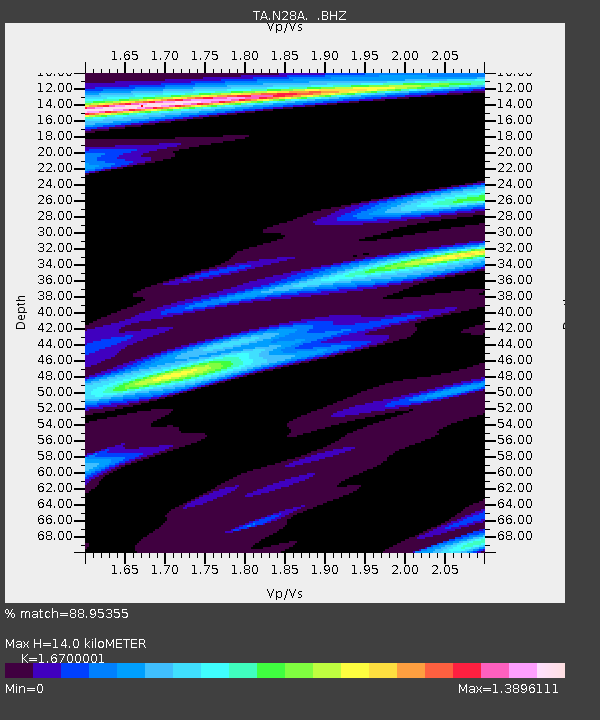
| Estimated Moho Depth: |
14.0 km |
| Estimated Crust Vp/Vs: |
1.67 |
| Assumed Crust Vp: |
6.483 km/s |
| Estimated Crust Vs: |
3.882 km/s |
| Estimated Crust Poisson's Ratio: |
0.22 |
|
| Radial Match: |
88.95355 % |
| Radial Bump: |
300 |
| Transverse Match: |
83.194626 % |
| Transverse Bump: |
314 |
| SOD ConfigId: |
346946 |
| Insert Time: |
2011-07-04 07:18:09.784 +0000 |
| GWidth: |
2.5 |
| Max Bumps: |
400 |
| Tol: |
0.001 |
|
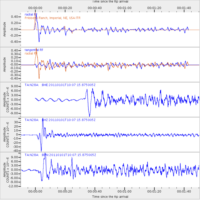
Signal To Noise
| Channel | StoN | STA | LTA |
| TA:N28A: :BHZ:20110101T10:07:15.875005Z | 59.724045 | 1.3678268E-5 | 2.2902448E-7 |
| TA:N28A: :BHN:20110101T10:07:15.875005Z | 4.118352 | 2.9755286E-6 | 7.2250464E-7 |
| TA:N28A: :BHE:20110101T10:07:15.875005Z | 3.8603868 | 2.3884331E-6 | 6.1870304E-7 |
| Arrivals |
| Ps | 1.5 SECOND |
| PpPs | 5.6 SECOND |
| PsPs/PpSs | 7.1 SECOND |


