You are here: Home > Network List > TA - USArray Transportable Network (new EarthScope stations) Stations List
> Station K28A Ten Mile Ranch, Cody, NE, USA > Earthquake Result Viewer
K28A Ten Mile Ranch, Cody, NE, USA - Earthquake Result Viewer
*The percent match for this event was below the threshold and hence no stack was calculated.
| Earthquake location: |
Santiago Del Estero Prov., Arg. |
| Earthquake latitude/longitude: |
-26.8/-63.1 |
| Earthquake time(UTC): |
2011/01/01 (001) 09:56:58 GMT |
| Earthquake Depth: |
577 km |
| Earthquake Magnitude: |
6.8 MB, 7.0 MW, 7.0 MW |
| Earthquake Catalog/Contributor: |
WHDF/NEIC |
|
| Network: |
TA USArray Transportable Network (new EarthScope stations) |
| Station: |
K28A Ten Mile Ranch, Cody, NE, USA |
| Lat/Lon: |
42.71 N/101.37 W |
| Elevation: |
986 m |
|
| Distance: |
77.6 deg |
| Az: |
332.164 deg |
| Baz: |
145.511 deg |
| Ray Param: |
$rayparam |
*The percent match for this event was below the threshold and hence was not used in the summary stack. |
|
| Radial Match: |
92.86932 % |
| Radial Bump: |
297 |
| Transverse Match: |
81.097946 % |
| Transverse Bump: |
400 |
| SOD ConfigId: |
346946 |
| Insert Time: |
2011-07-04 07:19:28.198 +0000 |
| GWidth: |
2.5 |
| Max Bumps: |
400 |
| Tol: |
0.001 |
|
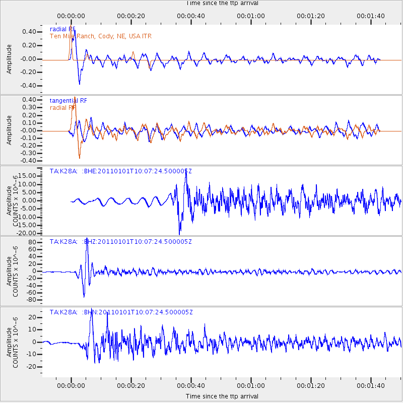
Signal To Noise
| Channel | StoN | STA | LTA |
| TA:K28A: :BHZ:20110101T10:07:24.500005Z | 56.929977 | 2.1703489E-5 | 3.8123127E-7 |
| TA:K28A: :BHN:20110101T10:07:24.500005Z | 1.6767464 | 2.033118E-6 | 1.2125377E-6 |
| TA:K28A: :BHE:20110101T10:07:24.500005Z | 1.9868014 | 2.57662E-6 | 1.2968685E-6 |
| Arrivals |
| Ps | |
| PpPs | |
| PsPs/PpSs | |


