You are here: Home > Network List > TA - USArray Transportable Network (new EarthScope stations) Stations List
> Station L29A Maesberg Ranch, Thedford, NE, USA > Earthquake Result Viewer
L29A Maesberg Ranch, Thedford, NE, USA - Earthquake Result Viewer
| Earthquake location: |
Santiago Del Estero Prov., Arg. |
| Earthquake latitude/longitude: |
-26.8/-63.1 |
| Earthquake time(UTC): |
2011/01/01 (001) 09:56:58 GMT |
| Earthquake Depth: |
577 km |
| Earthquake Magnitude: |
6.8 MB, 7.0 MW, 7.0 MW |
| Earthquake Catalog/Contributor: |
WHDF/NEIC |
|
| Network: |
TA USArray Transportable Network (new EarthScope stations) |
| Station: |
L29A Maesberg Ranch, Thedford, NE, USA |
| Lat/Lon: |
42.06 N/100.48 W |
| Elevation: |
901 m |
|
| Distance: |
76.7 deg |
| Az: |
332.349 deg |
| Baz: |
146.149 deg |
| Ray Param: |
0.048976447 |
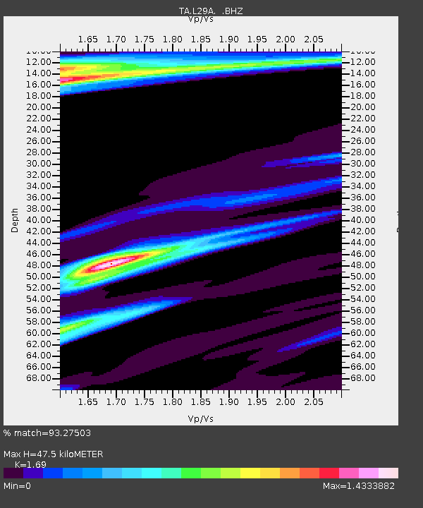
| Estimated Moho Depth: |
47.5 km |
| Estimated Crust Vp/Vs: |
1.69 |
| Assumed Crust Vp: |
6.483 km/s |
| Estimated Crust Vs: |
3.836 km/s |
| Estimated Crust Poisson's Ratio: |
0.23 |
|
| Radial Match: |
93.27503 % |
| Radial Bump: |
278 |
| Transverse Match: |
84.45377 % |
| Transverse Bump: |
327 |
| SOD ConfigId: |
346946 |
| Insert Time: |
2011-07-04 07:19:52.902 +0000 |
| GWidth: |
2.5 |
| Max Bumps: |
400 |
| Tol: |
0.001 |
|
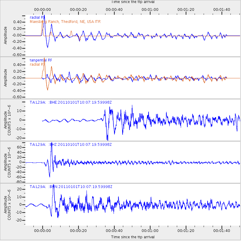
Signal To Noise
| Channel | StoN | STA | LTA |
| TA:L29A: :BHZ:20110101T10:07:19.59998Z | 87.17808 | 2.1938768E-5 | 2.5165465E-7 |
| TA:L29A: :BHN:20110101T10:07:19.59998Z | 3.0807545 | 3.831355E-6 | 1.2436418E-6 |
| TA:L29A: :BHE:20110101T10:07:19.59998Z | 3.1926682 | 2.8532024E-6 | 8.9367336E-7 |
| Arrivals |
| Ps | 5.2 SECOND |
| PpPs | 19 SECOND |
| PsPs/PpSs | 24 SECOND |


