You are here: Home > Network List > TA - USArray Transportable Network (new EarthScope stations) Stations List
> Station L28A Connealy Angus Ranch, Whitman, NE, USA > Earthquake Result Viewer
L28A Connealy Angus Ranch, Whitman, NE, USA - Earthquake Result Viewer
| Earthquake location: |
Santiago Del Estero Prov., Arg. |
| Earthquake latitude/longitude: |
-26.8/-63.1 |
| Earthquake time(UTC): |
2011/01/01 (001) 09:56:58 GMT |
| Earthquake Depth: |
577 km |
| Earthquake Magnitude: |
6.8 MB, 7.0 MW, 7.0 MW |
| Earthquake Catalog/Contributor: |
WHDF/NEIC |
|
| Network: |
TA USArray Transportable Network (new EarthScope stations) |
| Station: |
L28A Connealy Angus Ranch, Whitman, NE, USA |
| Lat/Lon: |
42.01 N/101.52 W |
| Elevation: |
1155 m |
|
| Distance: |
77.1 deg |
| Az: |
331.658 deg |
| Baz: |
145.297 deg |
| Ray Param: |
0.048721243 |
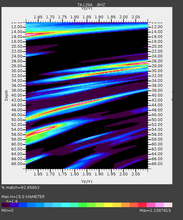
| Estimated Moho Depth: |
15.0 km |
| Estimated Crust Vp/Vs: |
1.60 |
| Assumed Crust Vp: |
6.483 km/s |
| Estimated Crust Vs: |
4.052 km/s |
| Estimated Crust Poisson's Ratio: |
0.18 |
|
| Radial Match: |
92.65653 % |
| Radial Bump: |
400 |
| Transverse Match: |
88.95581 % |
| Transverse Bump: |
400 |
| SOD ConfigId: |
346946 |
| Insert Time: |
2011-07-04 07:19:59.484 +0000 |
| GWidth: |
2.5 |
| Max Bumps: |
400 |
| Tol: |
0.001 |
|

Signal To Noise
| Channel | StoN | STA | LTA |
| TA:L28A: :BHZ:20110101T10:07:21.72498Z | 71.039925 | 1.9463829E-5 | 2.739844E-7 |
| TA:L28A: :BHN:20110101T10:07:21.72498Z | 5.859176 | 3.9947918E-6 | 6.8180094E-7 |
| TA:L28A: :BHE:20110101T10:07:21.72498Z | 2.4712102 | 2.0529112E-6 | 8.307311E-7 |
| Arrivals |
| Ps | 1.4 SECOND |
| PpPs | 5.8 SECOND |
| PsPs/PpSs | 7.3 SECOND |


