You are here: Home > Network List > TA - USArray Transportable Network (new EarthScope stations) Stations List
> Station F25A Bowman, SD, USA > Earthquake Result Viewer
F25A Bowman, SD, USA - Earthquake Result Viewer

| Earthquake location: |
Santiago Del Estero Prov., Arg. |
| Earthquake latitude/longitude: |
-26.8/-63.1 |
| Earthquake time(UTC): |
2011/01/01 (001) 09:56:58 GMT |
| Earthquake Depth: |
577 km |
| Earthquake Magnitude: |
6.8 MB, 7.0 MW, 7.0 MW |
| Earthquake Catalog/Contributor: |
WHDF/NEIC |
|
| Network: |
TA USArray Transportable Network (new EarthScope stations) |
| Station: |
F25A Bowman, SD, USA |
| Lat/Lon: |
45.93 N/103.46 W |
| Elevation: |
912 m |
|
| Distance: |
81.1 deg |
| Az: |
332.797 deg |
| Baz: |
144.171 deg |
| Ray Param: |
0.046063952 |
| Estimated Moho Depth: |
37.25 km |
| Estimated Crust Vp/Vs: |
2.08 |
| Assumed Crust Vp: |
6.242 km/s |
| Estimated Crust Vs: |
2.997 km/s |
| Estimated Crust Poisson's Ratio: |
0.35 |
|
| Radial Match: |
89.07699 % |
| Radial Bump: |
400 |
| Transverse Match: |
69.38648 % |
| Transverse Bump: |
400 |
| SOD ConfigId: |
346946 |
| Insert Time: |
2011-07-04 07:23:15.323 +0000 |
| GWidth: |
2.5 |
| Max Bumps: |
400 |
| Tol: |
0.001 |
|
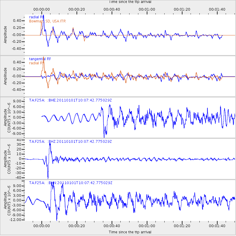
Signal To Noise
| Channel | StoN | STA | LTA |
| TA:F25A: :BHZ:20110101T10:07:42.775029Z | 44.37015 | 1.546149E-5 | 3.48466E-7 |
| TA:F25A: :BHN:20110101T10:07:42.775029Z | 2.6817763 | 2.8377067E-6 | 1.0581444E-6 |
| TA:F25A: :BHE:20110101T10:07:42.775029Z | 1.6943738 | 2.5124302E-6 | 1.4828075E-6 |
| Arrivals |
| Ps | 6.6 SECOND |
| PpPs | 18 SECOND |
| PsPs/PpSs | 25 SECOND |


