You are here: Home > Network List > TA - USArray Transportable Network (new EarthScope stations) Stations List
> Station D28A Regan, ND, USA > Earthquake Result Viewer
D28A Regan, ND, USA - Earthquake Result Viewer
| Earthquake location: |
Santiago Del Estero Prov., Arg. |
| Earthquake latitude/longitude: |
-26.8/-63.1 |
| Earthquake time(UTC): |
2011/01/01 (001) 09:56:58 GMT |
| Earthquake Depth: |
577 km |
| Earthquake Magnitude: |
6.8 MB, 7.0 MW, 7.0 MW |
| Earthquake Catalog/Contributor: |
WHDF/NEIC |
|
| Network: |
TA USArray Transportable Network (new EarthScope stations) |
| Station: |
D28A Regan, ND, USA |
| Lat/Lon: |
47.19 N/100.57 W |
| Elevation: |
621 m |
|
| Distance: |
81.0 deg |
| Az: |
335.186 deg |
| Baz: |
146.633 deg |
| Ray Param: |
0.046124123 |
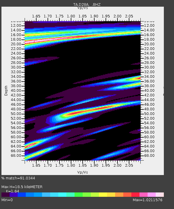
| Estimated Moho Depth: |
18.5 km |
| Estimated Crust Vp/Vs: |
1.64 |
| Assumed Crust Vp: |
6.438 km/s |
| Estimated Crust Vs: |
3.925 km/s |
| Estimated Crust Poisson's Ratio: |
0.20 |
|
| Radial Match: |
91.0344 % |
| Radial Bump: |
318 |
| Transverse Match: |
73.46151 % |
| Transverse Bump: |
326 |
| SOD ConfigId: |
346946 |
| Insert Time: |
2011-07-04 07:26:18.014 +0000 |
| GWidth: |
2.5 |
| Max Bumps: |
400 |
| Tol: |
0.001 |
|
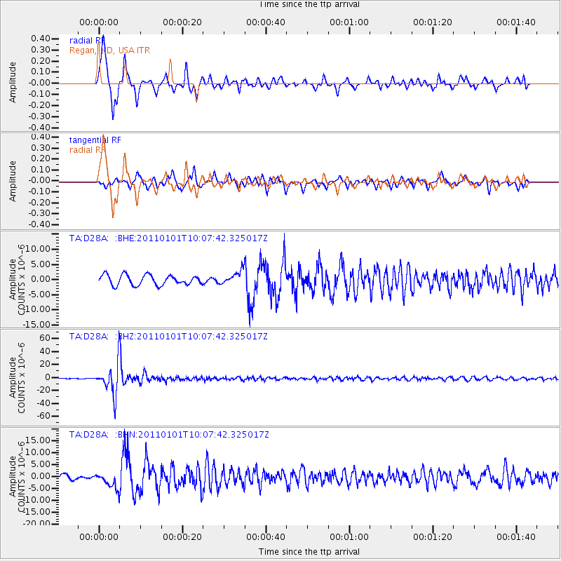
Signal To Noise
| Channel | StoN | STA | LTA |
| TA:D28A: :BHZ:20110101T10:07:42.325017Z | 76.62891 | 2.4034447E-5 | 3.1364726E-7 |
| TA:D28A: :BHN:20110101T10:07:42.325017Z | 3.4834397 | 3.3659414E-6 | 9.662695E-7 |
| TA:D28A: :BHE:20110101T10:07:42.325017Z | 1.4097285 | 2.3368868E-6 | 1.6576857E-6 |
| Arrivals |
| Ps | 1.9 SECOND |
| PpPs | 7.4 SECOND |
| PsPs/PpSs | 9.3 SECOND |


