You are here: Home > Network List > TA - USArray Transportable Network (new EarthScope stations) Stations List
> Station C30A Mose, Pekin, ND, USA > Earthquake Result Viewer
C30A Mose, Pekin, ND, USA - Earthquake Result Viewer
| Earthquake location: |
Santiago Del Estero Prov., Arg. |
| Earthquake latitude/longitude: |
-26.8/-63.1 |
| Earthquake time(UTC): |
2011/01/01 (001) 09:56:58 GMT |
| Earthquake Depth: |
577 km |
| Earthquake Magnitude: |
6.8 MB, 7.0 MW, 7.0 MW |
| Earthquake Catalog/Contributor: |
WHDF/NEIC |
|
| Network: |
TA USArray Transportable Network (new EarthScope stations) |
| Station: |
C30A Mose, Pekin, ND, USA |
| Lat/Lon: |
47.70 N/98.48 W |
| Elevation: |
480 m |
|
| Distance: |
80.7 deg |
| Az: |
336.676 deg |
| Baz: |
148.405 deg |
| Ray Param: |
0.046349898 |
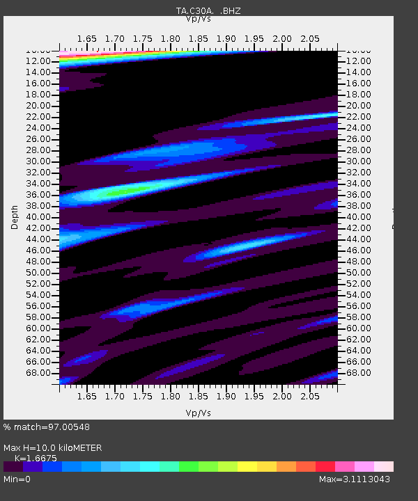
| Estimated Moho Depth: |
10.0 km |
| Estimated Crust Vp/Vs: |
1.67 |
| Assumed Crust Vp: |
6.53 km/s |
| Estimated Crust Vs: |
3.916 km/s |
| Estimated Crust Poisson's Ratio: |
0.22 |
|
| Radial Match: |
97.00548 % |
| Radial Bump: |
368 |
| Transverse Match: |
92.04632 % |
| Transverse Bump: |
383 |
| SOD ConfigId: |
346946 |
| Insert Time: |
2011-07-04 07:26:54.131 +0000 |
| GWidth: |
2.5 |
| Max Bumps: |
400 |
| Tol: |
0.001 |
|
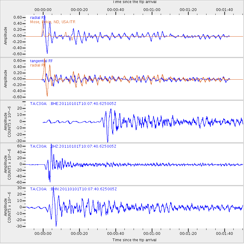
Signal To Noise
| Channel | StoN | STA | LTA |
| TA:C30A: :BHZ:20110101T10:07:40.625005Z | 55.371403 | 2.6333912E-5 | 4.7558686E-7 |
| TA:C30A: :BHN:20110101T10:07:40.625005Z | 8.349957 | 6.027001E-6 | 7.218002E-7 |
| TA:C30A: :BHE:20110101T10:07:40.625005Z | 4.8977304 | 5.5696078E-6 | 1.1371814E-6 |
| Arrivals |
| Ps | 1.1 SECOND |
| PpPs | 4.0 SECOND |
| PsPs/PpSs | 5.0 SECOND |


