You are here: Home > Network List > TA - USArray Transportable Network (new EarthScope stations) Stations List
> Station A28A Rude Farm, Bottineau, ND, USA > Earthquake Result Viewer
A28A Rude Farm, Bottineau, ND, USA - Earthquake Result Viewer

| Earthquake location: |
Santiago Del Estero Prov., Arg. |
| Earthquake latitude/longitude: |
-26.8/-63.1 |
| Earthquake time(UTC): |
2011/01/01 (001) 09:56:58 GMT |
| Earthquake Depth: |
577 km |
| Earthquake Magnitude: |
6.8 MB, 7.0 MW, 7.0 MW |
| Earthquake Catalog/Contributor: |
WHDF/NEIC |
|
| Network: |
TA USArray Transportable Network (new EarthScope stations) |
| Station: |
A28A Rude Farm, Bottineau, ND, USA |
| Lat/Lon: |
48.91 N/100.27 W |
| Elevation: |
692 m |
|
| Distance: |
82.4 deg |
| Az: |
336.308 deg |
| Baz: |
147.019 deg |
| Ray Param: |
0.045226138 |
| Estimated Moho Depth: |
16.0 km |
| Estimated Crust Vp/Vs: |
1.60 |
| Assumed Crust Vp: |
6.438 km/s |
| Estimated Crust Vs: |
4.023 km/s |
| Estimated Crust Poisson's Ratio: |
0.18 |
|
| Radial Match: |
85.71237 % |
| Radial Bump: |
317 |
| Transverse Match: |
70.10032 % |
| Transverse Bump: |
400 |
| SOD ConfigId: |
346946 |
| Insert Time: |
2011-07-04 07:27:14.780 +0000 |
| GWidth: |
2.5 |
| Max Bumps: |
400 |
| Tol: |
0.001 |
|
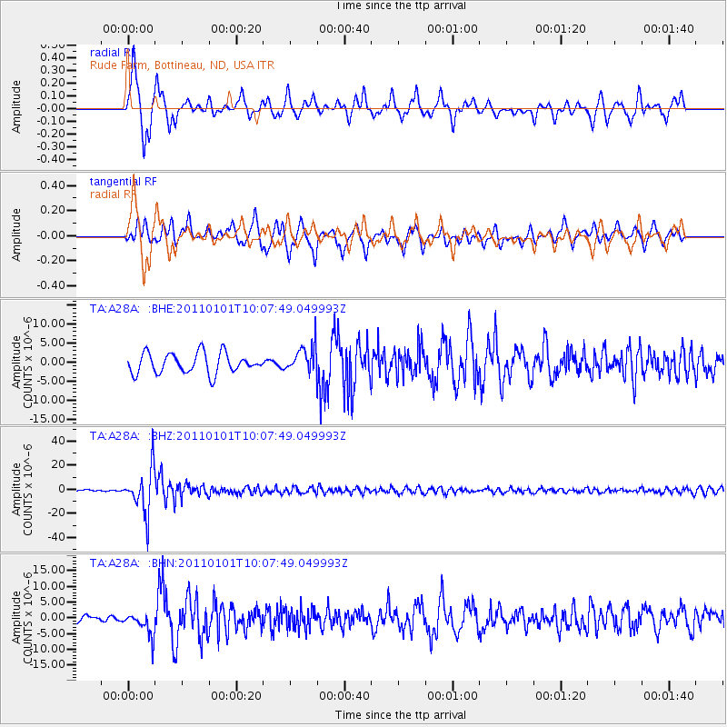
Signal To Noise
| Channel | StoN | STA | LTA |
| TA:A28A: :BHZ:20110101T10:07:49.049993Z | 37.25569 | 1.842682E-5 | 4.9460414E-7 |
| TA:A28A: :BHN:20110101T10:07:49.049993Z | 1.8273607 | 3.7491932E-6 | 2.0516984E-6 |
| TA:A28A: :BHE:20110101T10:07:49.049993Z | 1.321255 | 3.499457E-6 | 2.6485857E-6 |
| Arrivals |
| Ps | 1.5 SECOND |
| PpPs | 6.3 SECOND |
| PsPs/PpSs | 7.8 SECOND |


