You are here: Home > Network List > TA - USArray Transportable Network (new EarthScope stations) Stations List
> Station E29A Napoleon, ND, USA > Earthquake Result Viewer
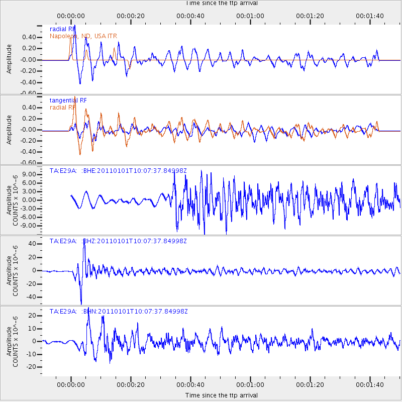
E29A Napoleon, ND, USA - Earthquake Result Viewer
*The percent match for this event was below the threshold and hence no stack was calculated.
| Earthquake location: |
Santiago Del Estero Prov., Arg. |
| Earthquake latitude/longitude: |
-26.8/-63.1 |
| Earthquake time(UTC): |
2011/01/01 (001) 09:56:58 GMT |
| Earthquake Depth: |
577 km |
| Earthquake Magnitude: |
6.8 MB, 7.0 MW, 7.0 MW |
| Earthquake Catalog/Contributor: |
WHDF/NEIC |
|
| Network: |
TA USArray Transportable Network (new EarthScope stations) |
| Station: |
E29A Napoleon, ND, USA |
| Lat/Lon: |
46.57 N/99.64 W |
| Elevation: |
628 m |
|
| Distance: |
80.2 deg |
| Az: |
335.382 deg |
| Baz: |
147.34 deg |
| Ray Param: |
$rayparam |
*The percent match for this event was below the threshold and hence was not used in the summary stack. |
|
| Radial Match: |
87.98384 % |
| Radial Bump: |
323 |
| Transverse Match: |
71.37278 % |
| Transverse Bump: |
400 |
| SOD ConfigId: |
346946 |
| Insert Time: |
2011-07-04 07:28:21.329 +0000 |
| GWidth: |
2.5 |
| Max Bumps: |
400 |
| Tol: |
0.001 |
|
Signal To Noise
| Channel | StoN | STA | LTA |
| TA:E29A: :BHZ:20110101T10:07:37.84998Z | 44.49303 | 2.0109854E-5 | 4.5197763E-7 |
| TA:E29A: :BHN:20110101T10:07:37.84998Z | 2.4689603 | 3.7741318E-6 | 1.528632E-6 |
| TA:E29A: :BHE:20110101T10:07:37.84998Z | 2.2591567 | 2.8173579E-6 | 1.2470839E-6 |
| Arrivals |
| Ps | |
| PpPs | |
| PsPs/PpSs | |


