You are here: Home > Network List > TA - USArray Transportable Network (new EarthScope stations) Stations List
> Station L30A Spencer Herefords Ranch, Brewster, NE, USA > Earthquake Result Viewer
L30A Spencer Herefords Ranch, Brewster, NE, USA - Earthquake Result Viewer

| Earthquake location: |
Santiago Del Estero Prov., Arg. |
| Earthquake latitude/longitude: |
-26.8/-63.1 |
| Earthquake time(UTC): |
2011/01/01 (001) 09:56:58 GMT |
| Earthquake Depth: |
577 km |
| Earthquake Magnitude: |
6.8 MB, 7.0 MW, 7.0 MW |
| Earthquake Catalog/Contributor: |
WHDF/NEIC |
|
| Network: |
TA USArray Transportable Network (new EarthScope stations) |
| Station: |
L30A Spencer Herefords Ranch, Brewster, NE, USA |
| Lat/Lon: |
41.95 N/99.72 W |
| Elevation: |
782 m |
|
| Distance: |
76.3 deg |
| Az: |
332.768 deg |
| Baz: |
146.752 deg |
| Ray Param: |
0.04924333 |
| Estimated Moho Depth: |
69.5 km |
| Estimated Crust Vp/Vs: |
1.92 |
| Assumed Crust Vp: |
6.53 km/s |
| Estimated Crust Vs: |
3.392 km/s |
| Estimated Crust Poisson's Ratio: |
0.32 |
|
| Radial Match: |
94.35851 % |
| Radial Bump: |
300 |
| Transverse Match: |
88.14598 % |
| Transverse Bump: |
366 |
| SOD ConfigId: |
346946 |
| Insert Time: |
2011-07-04 07:28:52.733 +0000 |
| GWidth: |
2.5 |
| Max Bumps: |
400 |
| Tol: |
0.001 |
|
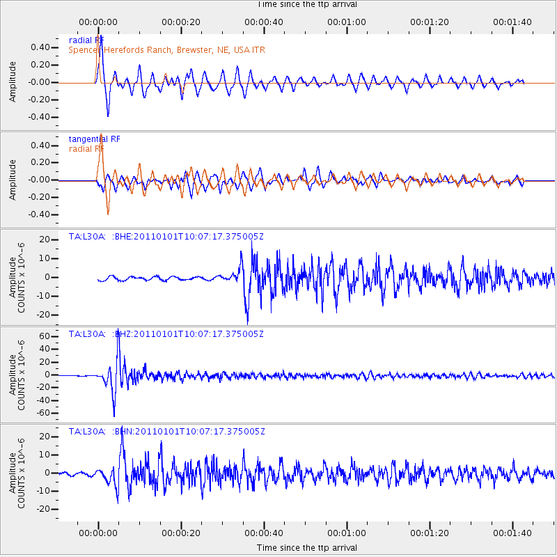
Signal To Noise
| Channel | StoN | STA | LTA |
| TA:L30A: :BHZ:20110101T10:07:17.375005Z | 92.60039 | 2.423855E-5 | 2.617543E-7 |
| TA:L30A: :BHN:20110101T10:07:17.375005Z | 5.6386867 | 5.039165E-6 | 8.9367705E-7 |
| TA:L30A: :BHE:20110101T10:07:17.375005Z | 4.444694 | 4.081068E-6 | 9.181887E-7 |
| Arrivals |
| Ps | 10 SECOND |
| PpPs | 30 SECOND |
| PsPs/PpSs | 40 SECOND |


