You are here: Home > Network List > TA - USArray Transportable Network (new EarthScope stations) Stations List
> Station N32A Stulken Farm, Doniphan, NE, USA > Earthquake Result Viewer
N32A Stulken Farm, Doniphan, NE, USA - Earthquake Result Viewer
| Earthquake location: |
Santiago Del Estero Prov., Arg. |
| Earthquake latitude/longitude: |
-26.8/-63.1 |
| Earthquake time(UTC): |
2011/01/01 (001) 09:56:58 GMT |
| Earthquake Depth: |
577 km |
| Earthquake Magnitude: |
6.8 MB, 7.0 MW, 7.0 MW |
| Earthquake Catalog/Contributor: |
WHDF/NEIC |
|
| Network: |
TA USArray Transportable Network (new EarthScope stations) |
| Station: |
N32A Stulken Farm, Doniphan, NE, USA |
| Lat/Lon: |
40.76 N/98.30 W |
| Elevation: |
587 m |
|
| Distance: |
74.7 deg |
| Az: |
333.038 deg |
| Baz: |
147.757 deg |
| Ray Param: |
0.05026515 |
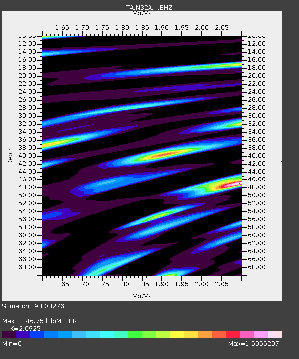
| Estimated Moho Depth: |
46.75 km |
| Estimated Crust Vp/Vs: |
2.09 |
| Assumed Crust Vp: |
6.53 km/s |
| Estimated Crust Vs: |
3.121 km/s |
| Estimated Crust Poisson's Ratio: |
0.35 |
|
| Radial Match: |
93.08276 % |
| Radial Bump: |
400 |
| Transverse Match: |
91.45854 % |
| Transverse Bump: |
400 |
| SOD ConfigId: |
346946 |
| Insert Time: |
2011-07-04 07:29:05.199 +0000 |
| GWidth: |
2.5 |
| Max Bumps: |
400 |
| Tol: |
0.001 |
|

Signal To Noise
| Channel | StoN | STA | LTA |
| TA:N32A: :BHZ:20110101T10:07:08.674993Z | 54.83628 | 1.6264341E-5 | 2.9659816E-7 |
| TA:N32A: :BHN:20110101T10:07:08.674993Z | 12.013627 | 6.2041286E-6 | 5.164243E-7 |
| TA:N32A: :BHE:20110101T10:07:08.674993Z | 10.904631 | 5.0744666E-6 | 4.6534967E-7 |
| Arrivals |
| Ps | 8.0 SECOND |
| PpPs | 22 SECOND |
| PsPs/PpSs | 30 SECOND |


