You are here: Home > Network List > TA - USArray Transportable Network (new EarthScope stations) Stations List
> Station F30A Leola, SD, USA > Earthquake Result Viewer
F30A Leola, SD, USA - Earthquake Result Viewer
| Earthquake location: |
Santiago Del Estero Prov., Arg. |
| Earthquake latitude/longitude: |
-26.8/-63.1 |
| Earthquake time(UTC): |
2011/01/01 (001) 09:56:58 GMT |
| Earthquake Depth: |
577 km |
| Earthquake Magnitude: |
6.8 MB, 7.0 MW, 7.0 MW |
| Earthquake Catalog/Contributor: |
WHDF/NEIC |
|
| Network: |
TA USArray Transportable Network (new EarthScope stations) |
| Station: |
F30A Leola, SD, USA |
| Lat/Lon: |
45.84 N/99.03 W |
| Elevation: |
601 m |
|
| Distance: |
79.3 deg |
| Az: |
335.35 deg |
| Baz: |
147.778 deg |
| Ray Param: |
0.047271334 |
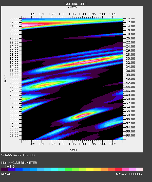
| Estimated Moho Depth: |
13.5 km |
| Estimated Crust Vp/Vs: |
1.60 |
| Assumed Crust Vp: |
6.53 km/s |
| Estimated Crust Vs: |
4.082 km/s |
| Estimated Crust Poisson's Ratio: |
0.18 |
|
| Radial Match: |
92.469086 % |
| Radial Bump: |
293 |
| Transverse Match: |
79.96079 % |
| Transverse Bump: |
300 |
| SOD ConfigId: |
346946 |
| Insert Time: |
2011-07-04 07:29:06.611 +0000 |
| GWidth: |
2.5 |
| Max Bumps: |
400 |
| Tol: |
0.001 |
|

Signal To Noise
| Channel | StoN | STA | LTA |
| TA:F30A: :BHZ:20110101T10:07:33.424993Z | 40.729446 | 1.9226618E-5 | 4.7205694E-7 |
| TA:F30A: :BHN:20110101T10:07:33.424993Z | 4.5469093 | 6.300739E-6 | 1.385719E-6 |
| TA:F30A: :BHE:20110101T10:07:33.424993Z | 2.5230904 | 3.2451812E-6 | 1.286193E-6 |
| Arrivals |
| Ps | 1.3 SECOND |
| PpPs | 5.2 SECOND |
| PsPs/PpSs | 6.5 SECOND |


