You are here: Home > Network List > TA - USArray Transportable Network (new EarthScope stations) Stations List
> Station G30A Faulkton, SD, USA > Earthquake Result Viewer
G30A Faulkton, SD, USA - Earthquake Result Viewer
| Earthquake location: |
Santiago Del Estero Prov., Arg. |
| Earthquake latitude/longitude: |
-26.8/-63.1 |
| Earthquake time(UTC): |
2011/01/01 (001) 09:56:58 GMT |
| Earthquake Depth: |
577 km |
| Earthquake Magnitude: |
6.8 MB, 7.0 MW, 7.0 MW |
| Earthquake Catalog/Contributor: |
WHDF/NEIC |
|
| Network: |
TA USArray Transportable Network (new EarthScope stations) |
| Station: |
G30A Faulkton, SD, USA |
| Lat/Lon: |
45.13 N/99.14 W |
| Elevation: |
496 m |
|
| Distance: |
78.8 deg |
| Az: |
334.893 deg |
| Baz: |
147.606 deg |
| Ray Param: |
0.04764151 |
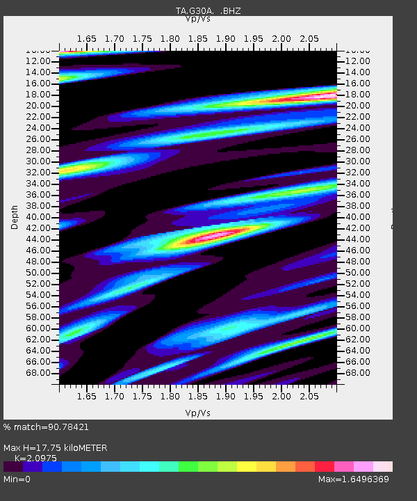
| Estimated Moho Depth: |
17.75 km |
| Estimated Crust Vp/Vs: |
2.10 |
| Assumed Crust Vp: |
6.53 km/s |
| Estimated Crust Vs: |
3.113 km/s |
| Estimated Crust Poisson's Ratio: |
0.35 |
|
| Radial Match: |
90.78421 % |
| Radial Bump: |
400 |
| Transverse Match: |
85.055046 % |
| Transverse Bump: |
400 |
| SOD ConfigId: |
346946 |
| Insert Time: |
2011-07-04 07:29:40.178 +0000 |
| GWidth: |
2.5 |
| Max Bumps: |
400 |
| Tol: |
0.001 |
|
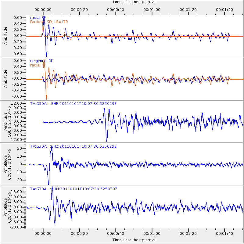
Signal To Noise
| Channel | StoN | STA | LTA |
| TA:G30A: :BHZ:20110101T10:07:30.525029Z | 38.767906 | 1.190123E-5 | 3.0698666E-7 |
| TA:G30A: :BHN:20110101T10:07:30.525029Z | 7.4629617 | 5.5377095E-6 | 7.420257E-7 |
| TA:G30A: :BHE:20110101T10:07:30.525029Z | 10.857362 | 3.8176368E-6 | 3.5161736E-7 |
| Arrivals |
| Ps | 3.1 SECOND |
| PpPs | 8.2 SECOND |
| PsPs/PpSs | 11 SECOND |


