You are here: Home > Network List > TA - USArray Transportable Network (new EarthScope stations) Stations List
> Station 433A Art, TX, USA > Earthquake Result Viewer
433A Art, TX, USA - Earthquake Result Viewer
| Earthquake location: |
Santiago Del Estero Prov., Arg. |
| Earthquake latitude/longitude: |
-26.8/-63.1 |
| Earthquake time(UTC): |
2011/01/01 (001) 09:56:58 GMT |
| Earthquake Depth: |
577 km |
| Earthquake Magnitude: |
6.8 MB, 7.0 MW, 7.0 MW |
| Earthquake Catalog/Contributor: |
WHDF/NEIC |
|
| Network: |
TA USArray Transportable Network (new EarthScope stations) |
| Station: |
433A Art, TX, USA |
| Lat/Lon: |
30.75 N/99.09 W |
| Elevation: |
447 m |
|
| Distance: |
66.8 deg |
| Az: |
326.626 deg |
| Baz: |
145.171 deg |
| Ray Param: |
0.05532274 |
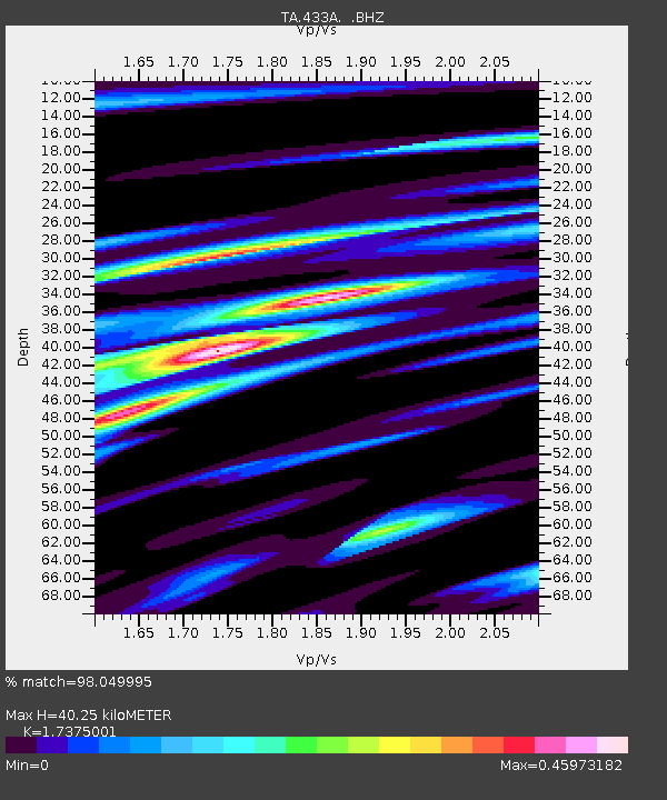
| Estimated Moho Depth: |
40.25 km |
| Estimated Crust Vp/Vs: |
1.74 |
| Assumed Crust Vp: |
6.498 km/s |
| Estimated Crust Vs: |
3.74 km/s |
| Estimated Crust Poisson's Ratio: |
0.25 |
|
| Radial Match: |
98.049995 % |
| Radial Bump: |
295 |
| Transverse Match: |
89.97243 % |
| Transverse Bump: |
372 |
| SOD ConfigId: |
346946 |
| Insert Time: |
2011-07-04 07:38:28.699 +0000 |
| GWidth: |
2.5 |
| Max Bumps: |
400 |
| Tol: |
0.001 |
|

Signal To Noise
| Channel | StoN | STA | LTA |
| TA:433A: :BHZ:20110101T10:06:22.000005Z | 102.82068 | 2.0188087E-5 | 1.9634268E-7 |
| TA:433A: :BHN:20110101T10:06:22.000005Z | 45.653763 | 6.106031E-6 | 1.3374651E-7 |
| TA:433A: :BHE:20110101T10:06:22.000005Z | 34.939396 | 4.294577E-6 | 1.2291504E-7 |
| Arrivals |
| Ps | 4.7 SECOND |
| PpPs | 16 SECOND |
| PsPs/PpSs | 21 SECOND |


