You are here: Home > Network List > TA - USArray Transportable Network (new EarthScope stations) Stations List
> Station 633A Saathoff Ranch, Hondo, TX, USA > Earthquake Result Viewer
633A Saathoff Ranch, Hondo, TX, USA - Earthquake Result Viewer
| Earthquake location: |
Santiago Del Estero Prov., Arg. |
| Earthquake latitude/longitude: |
-26.8/-63.1 |
| Earthquake time(UTC): |
2011/01/01 (001) 09:56:58 GMT |
| Earthquake Depth: |
577 km |
| Earthquake Magnitude: |
6.8 MB, 7.0 MW, 7.0 MW |
| Earthquake Catalog/Contributor: |
WHDF/NEIC |
|
| Network: |
TA USArray Transportable Network (new EarthScope stations) |
| Station: |
633A Saathoff Ranch, Hondo, TX, USA |
| Lat/Lon: |
29.46 N/99.18 W |
| Elevation: |
320 m |
|
| Distance: |
65.7 deg |
| Az: |
325.75 deg |
| Baz: |
144.775 deg |
| Ray Param: |
0.055961173 |
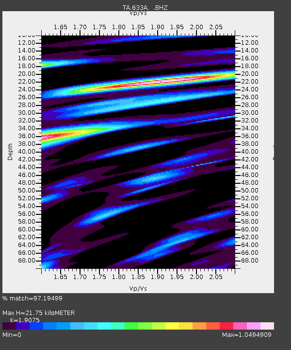
| Estimated Moho Depth: |
21.75 km |
| Estimated Crust Vp/Vs: |
1.91 |
| Assumed Crust Vp: |
6.347 km/s |
| Estimated Crust Vs: |
3.327 km/s |
| Estimated Crust Poisson's Ratio: |
0.31 |
|
| Radial Match: |
97.19499 % |
| Radial Bump: |
400 |
| Transverse Match: |
93.387215 % |
| Transverse Bump: |
400 |
| SOD ConfigId: |
346946 |
| Insert Time: |
2011-07-04 07:41:56.843 +0000 |
| GWidth: |
2.5 |
| Max Bumps: |
400 |
| Tol: |
0.001 |
|
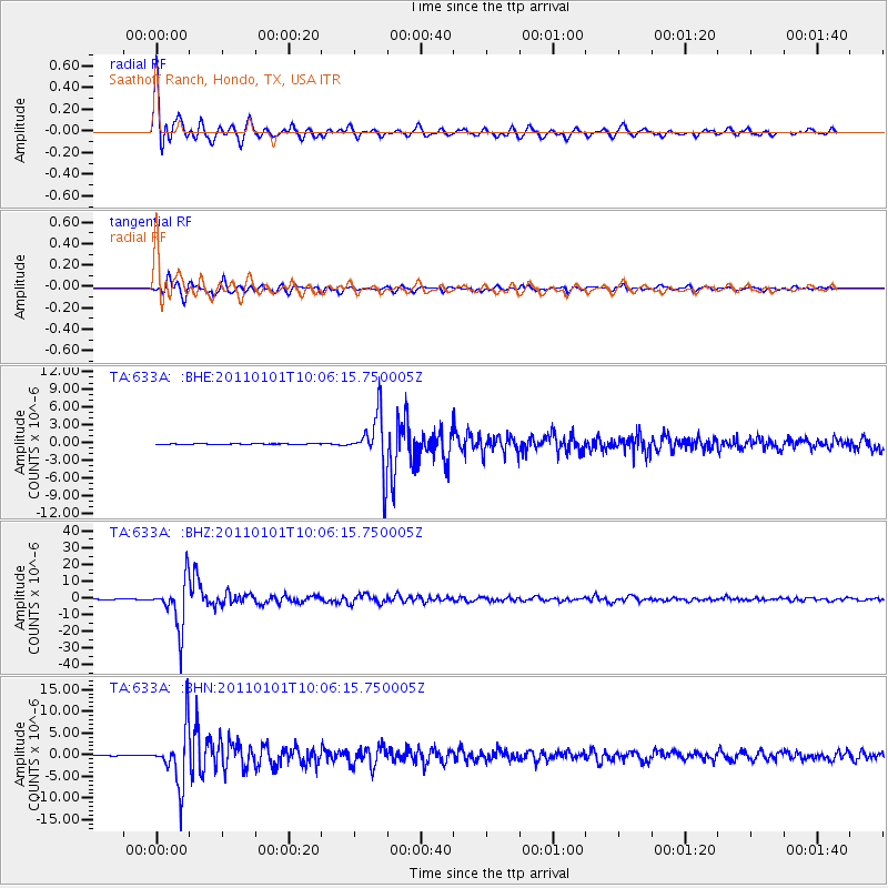
Signal To Noise
| Channel | StoN | STA | LTA |
| TA:633A: :BHZ:20110101T10:06:15.750005Z | 101.70914 | 1.4160517E-5 | 1.3922562E-7 |
| TA:633A: :BHN:20110101T10:06:15.750005Z | 42.40341 | 6.453894E-6 | 1.5220223E-7 |
| TA:633A: :BHE:20110101T10:06:15.750005Z | 54.996418 | 4.666377E-6 | 8.484874E-8 |
| Arrivals |
| Ps | 3.2 SECOND |
| PpPs | 9.6 SECOND |
| PsPs/PpSs | 13 SECOND |


