You are here: Home > Network List > TA - USArray Transportable Network (new EarthScope stations) Stations List
> Station 832A Faith Ranch, Carrizo Springs, TX, USA > Earthquake Result Viewer
832A Faith Ranch, Carrizo Springs, TX, USA - Earthquake Result Viewer
| Earthquake location: |
Santiago Del Estero Prov., Arg. |
| Earthquake latitude/longitude: |
-26.8/-63.1 |
| Earthquake time(UTC): |
2011/01/01 (001) 09:56:58 GMT |
| Earthquake Depth: |
577 km |
| Earthquake Magnitude: |
6.8 MB, 7.0 MW, 7.0 MW |
| Earthquake Catalog/Contributor: |
WHDF/NEIC |
|
| Network: |
TA USArray Transportable Network (new EarthScope stations) |
| Station: |
832A Faith Ranch, Carrizo Springs, TX, USA |
| Lat/Lon: |
28.28 N/99.97 W |
| Elevation: |
238 m |
|
| Distance: |
65.2 deg |
| Az: |
324.375 deg |
| Baz: |
143.821 deg |
| Ray Param: |
0.056298226 |
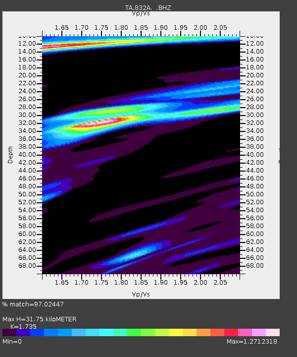
| Estimated Moho Depth: |
31.75 km |
| Estimated Crust Vp/Vs: |
1.74 |
| Assumed Crust Vp: |
6.347 km/s |
| Estimated Crust Vs: |
3.658 km/s |
| Estimated Crust Poisson's Ratio: |
0.25 |
|
| Radial Match: |
97.02447 % |
| Radial Bump: |
366 |
| Transverse Match: |
90.29445 % |
| Transverse Bump: |
400 |
| SOD ConfigId: |
346946 |
| Insert Time: |
2011-07-04 07:42:22.976 +0000 |
| GWidth: |
2.5 |
| Max Bumps: |
400 |
| Tol: |
0.001 |
|

Signal To Noise
| Channel | StoN | STA | LTA |
| TA:832A: :BHZ:20110101T10:06:12.375005Z | 82.52155 | 2.0974237E-5 | 2.541668E-7 |
| TA:832A: :BHN:20110101T10:06:12.375005Z | 27.274397 | 5.654147E-6 | 2.0730604E-7 |
| TA:832A: :BHE:20110101T10:06:12.375005Z | 10.738219 | 2.2599545E-6 | 2.1045898E-7 |
| Arrivals |
| Ps | 3.8 SECOND |
| PpPs | 13 SECOND |
| PsPs/PpSs | 17 SECOND |


