You are here: Home > Network List > TA - USArray Transportable Network (new EarthScope stations) Stations List
> Station 535A Dale, TX, USA > Earthquake Result Viewer
535A Dale, TX, USA - Earthquake Result Viewer
| Earthquake location: |
Santiago Del Estero Prov., Arg. |
| Earthquake latitude/longitude: |
-26.8/-63.1 |
| Earthquake time(UTC): |
2011/01/01 (001) 09:56:58 GMT |
| Earthquake Depth: |
577 km |
| Earthquake Magnitude: |
6.8 MB, 7.0 MW, 7.0 MW |
| Earthquake Catalog/Contributor: |
WHDF/NEIC |
|
| Network: |
TA USArray Transportable Network (new EarthScope stations) |
| Station: |
535A Dale, TX, USA |
| Lat/Lon: |
30.03 N/97.57 W |
| Elevation: |
170 m |
|
| Distance: |
65.4 deg |
| Az: |
327.367 deg |
| Baz: |
146.237 deg |
| Ray Param: |
0.05616176 |
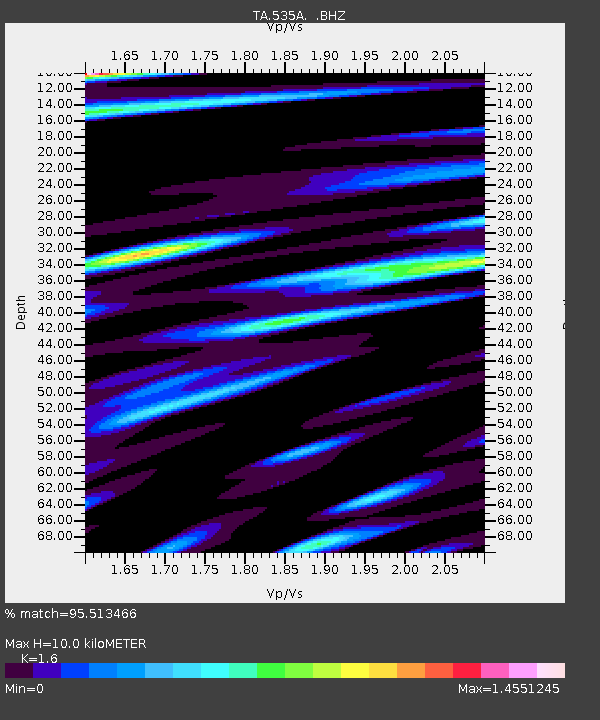
| Estimated Moho Depth: |
10.0 km |
| Estimated Crust Vp/Vs: |
1.60 |
| Assumed Crust Vp: |
6.347 km/s |
| Estimated Crust Vs: |
3.967 km/s |
| Estimated Crust Poisson's Ratio: |
0.18 |
|
| Radial Match: |
95.513466 % |
| Radial Bump: |
306 |
| Transverse Match: |
92.96457 % |
| Transverse Bump: |
336 |
| SOD ConfigId: |
346946 |
| Insert Time: |
2011-07-04 07:42:25.889 +0000 |
| GWidth: |
2.5 |
| Max Bumps: |
400 |
| Tol: |
0.001 |
|
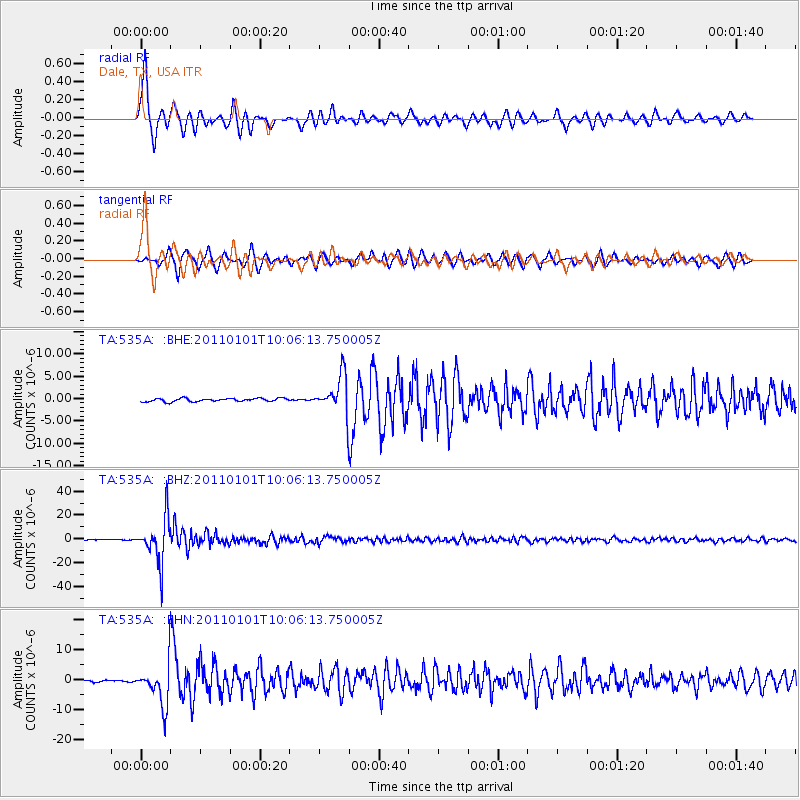
Signal To Noise
| Channel | StoN | STA | LTA |
| TA:535A: :BHZ:20110101T10:06:13.750005Z | 126.86607 | 1.8542874E-5 | 1.4616101E-7 |
| TA:535A: :BHN:20110101T10:06:13.750005Z | 26.34085 | 6.5461036E-6 | 2.4851528E-7 |
| TA:535A: :BHE:20110101T10:06:13.750005Z | 12.017234 | 4.271137E-6 | 3.5541765E-7 |
| Arrivals |
| Ps | 1.0 SECOND |
| PpPs | 3.9 SECOND |
| PsPs/PpSs | 4.9 SECOND |


