You are here: Home > Network List > TA - USArray Transportable Network (new EarthScope stations) Stations List
> Station 239A Gary, TX, USA > Earthquake Result Viewer
239A Gary, TX, USA - Earthquake Result Viewer
| Earthquake location: |
Santiago Del Estero Prov., Arg. |
| Earthquake latitude/longitude: |
-26.8/-63.1 |
| Earthquake time(UTC): |
2011/01/01 (001) 09:56:58 GMT |
| Earthquake Depth: |
577 km |
| Earthquake Magnitude: |
6.8 MB, 7.0 MW, 7.0 MW |
| Earthquake Catalog/Contributor: |
WHDF/NEIC |
|
| Network: |
TA USArray Transportable Network (new EarthScope stations) |
| Station: |
239A Gary, TX, USA |
| Lat/Lon: |
32.02 N/94.47 W |
| Elevation: |
100 m |
|
| Distance: |
65.7 deg |
| Az: |
331.002 deg |
| Baz: |
149.332 deg |
| Ray Param: |
0.056001354 |
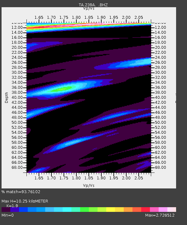
| Estimated Moho Depth: |
10.25 km |
| Estimated Crust Vp/Vs: |
1.90 |
| Assumed Crust Vp: |
6.245 km/s |
| Estimated Crust Vs: |
3.287 km/s |
| Estimated Crust Poisson's Ratio: |
0.31 |
|
| Radial Match: |
93.76102 % |
| Radial Bump: |
325 |
| Transverse Match: |
87.72041 % |
| Transverse Bump: |
338 |
| SOD ConfigId: |
346946 |
| Insert Time: |
2011-07-04 07:47:14.500 +0000 |
| GWidth: |
2.5 |
| Max Bumps: |
400 |
| Tol: |
0.001 |
|
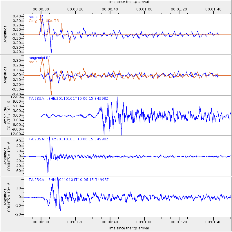
Signal To Noise
| Channel | StoN | STA | LTA |
| TA:239A: :BHZ:20110101T10:06:15.34998Z | 56.587666 | 2.1706484E-5 | 3.8359036E-7 |
| TA:239A: :BHN:20110101T10:06:15.34998Z | 6.230431 | 3.8574713E-6 | 6.1913386E-7 |
| TA:239A: :BHE:20110101T10:06:15.34998Z | 4.4618726 | 2.3152286E-6 | 5.188916E-7 |
| Arrivals |
| Ps | 1.5 SECOND |
| PpPs | 4.6 SECOND |
| PsPs/PpSs | 6.1 SECOND |


