You are here: Home > Network List > TA - USArray Transportable Network (new EarthScope stations) Stations List
> Station W38A Poteau, OK, USA > Earthquake Result Viewer
W38A Poteau, OK, USA - Earthquake Result Viewer
| Earthquake location: |
Santiago Del Estero Prov., Arg. |
| Earthquake latitude/longitude: |
-26.8/-63.1 |
| Earthquake time(UTC): |
2011/01/01 (001) 09:56:58 GMT |
| Earthquake Depth: |
577 km |
| Earthquake Magnitude: |
6.8 MB, 7.0 MW, 7.0 MW |
| Earthquake Catalog/Contributor: |
WHDF/NEIC |
|
| Network: |
TA USArray Transportable Network (new EarthScope stations) |
| Station: |
W38A Poteau, OK, USA |
| Lat/Lon: |
35.07 N/94.52 W |
| Elevation: |
169 m |
|
| Distance: |
68.3 deg |
| Az: |
332.636 deg |
| Baz: |
149.944 deg |
| Ray Param: |
0.05434224 |
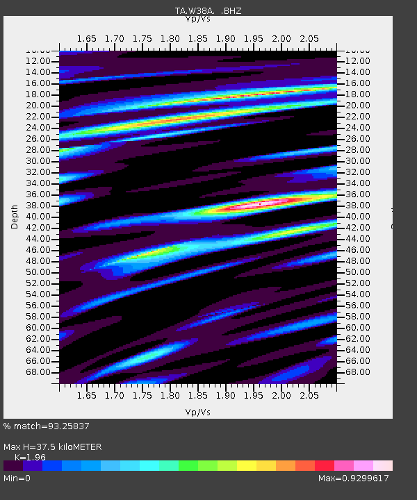
| Estimated Moho Depth: |
37.5 km |
| Estimated Crust Vp/Vs: |
1.96 |
| Assumed Crust Vp: |
6.498 km/s |
| Estimated Crust Vs: |
3.315 km/s |
| Estimated Crust Poisson's Ratio: |
0.32 |
|
| Radial Match: |
93.25837 % |
| Radial Bump: |
400 |
| Transverse Match: |
93.40415 % |
| Transverse Bump: |
400 |
| SOD ConfigId: |
346946 |
| Insert Time: |
2011-07-04 07:50:51.653 +0000 |
| GWidth: |
2.5 |
| Max Bumps: |
400 |
| Tol: |
0.001 |
|
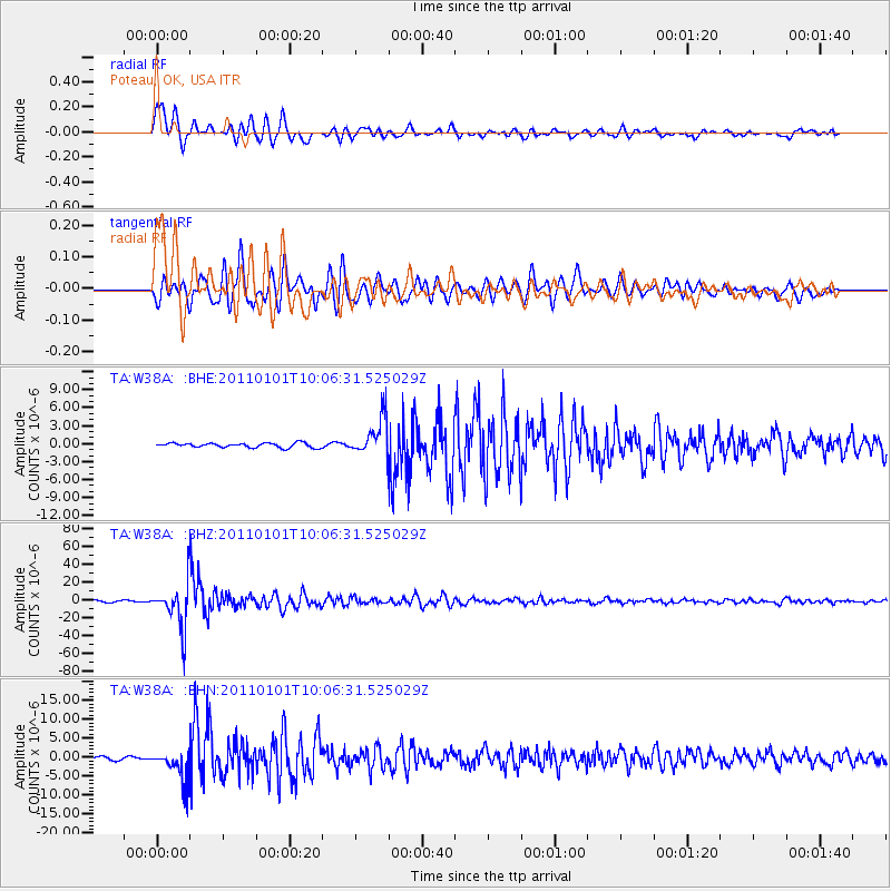
Signal To Noise
| Channel | StoN | STA | LTA |
| TA:W38A: :BHZ:20110101T10:06:31.525029Z | 26.314522 | 2.4561235E-5 | 9.333719E-7 |
| TA:W38A: :BHN:20110101T10:06:31.525029Z | 7.537066 | 4.143801E-6 | 5.4978966E-7 |
| TA:W38A: :BHE:20110101T10:06:31.525029Z | 8.222294 | 3.06354E-6 | 3.7258945E-7 |
| Arrivals |
| Ps | 5.7 SECOND |
| PpPs | 17 SECOND |
| PsPs/PpSs | 22 SECOND |


