You are here: Home > Network List > TA - USArray Transportable Network (new EarthScope stations) Stations List
> Station Z38A Mt. Pleasant, TX, USA > Earthquake Result Viewer
Z38A Mt. Pleasant, TX, USA - Earthquake Result Viewer
| Earthquake location: |
Santiago Del Estero Prov., Arg. |
| Earthquake latitude/longitude: |
-26.8/-63.1 |
| Earthquake time(UTC): |
2011/01/01 (001) 09:56:58 GMT |
| Earthquake Depth: |
577 km |
| Earthquake Magnitude: |
6.8 MB, 7.0 MW, 7.0 MW |
| Earthquake Catalog/Contributor: |
WHDF/NEIC |
|
| Network: |
TA USArray Transportable Network (new EarthScope stations) |
| Station: |
Z38A Mt. Pleasant, TX, USA |
| Lat/Lon: |
33.25 N/94.99 W |
| Elevation: |
116 m |
|
| Distance: |
67.0 deg |
| Az: |
331.28 deg |
| Baz: |
149.168 deg |
| Ray Param: |
0.05519762 |
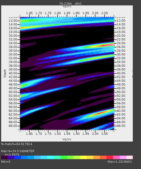
| Estimated Moho Depth: |
24.5 km |
| Estimated Crust Vp/Vs: |
2.10 |
| Assumed Crust Vp: |
6.245 km/s |
| Estimated Crust Vs: |
2.977 km/s |
| Estimated Crust Poisson's Ratio: |
0.35 |
|
| Radial Match: |
84.517914 % |
| Radial Bump: |
362 |
| Transverse Match: |
69.67036 % |
| Transverse Bump: |
400 |
| SOD ConfigId: |
346946 |
| Insert Time: |
2011-07-04 07:51:00.338 +0000 |
| GWidth: |
2.5 |
| Max Bumps: |
400 |
| Tol: |
0.001 |
|

Signal To Noise
| Channel | StoN | STA | LTA |
| TA:Z38A: :BHZ:20110101T10:06:23.22498Z | 39.377827 | 1.8243865E-5 | 4.63303E-7 |
| TA:Z38A: :BHN:20110101T10:06:23.22498Z | 5.026341 | 3.4691668E-6 | 6.901973E-7 |
| TA:Z38A: :BHE:20110101T10:06:23.22498Z | 2.8450854 | 2.7486112E-6 | 9.66091E-7 |
| Arrivals |
| Ps | 4.4 SECOND |
| PpPs | 12 SECOND |
| PsPs/PpSs | 16 SECOND |


