You are here: Home > Network List > TA - USArray Transportable Network (new EarthScope stations) Stations List
> Station T36A Boggs Farm, Caney, KS, USA > Earthquake Result Viewer
T36A Boggs Farm, Caney, KS, USA - Earthquake Result Viewer
| Earthquake location: |
Santiago Del Estero Prov., Arg. |
| Earthquake latitude/longitude: |
-26.8/-63.1 |
| Earthquake time(UTC): |
2011/01/01 (001) 09:56:58 GMT |
| Earthquake Depth: |
577 km |
| Earthquake Magnitude: |
6.8 MB, 7.0 MW, 7.0 MW |
| Earthquake Catalog/Contributor: |
WHDF/NEIC |
|
| Network: |
TA USArray Transportable Network (new EarthScope stations) |
| Station: |
T36A Boggs Farm, Caney, KS, USA |
| Lat/Lon: |
37.06 N/95.88 W |
| Elevation: |
243 m |
|
| Distance: |
70.6 deg |
| Az: |
332.696 deg |
| Baz: |
149.168 deg |
| Ray Param: |
0.052910358 |
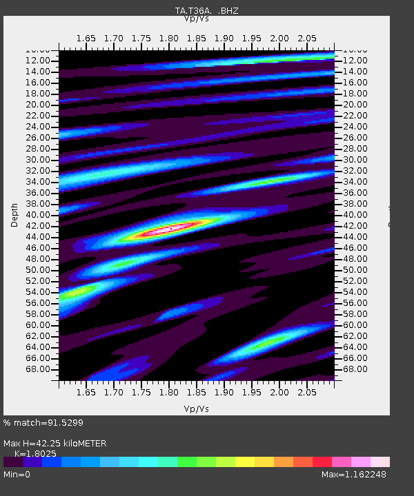
| Estimated Moho Depth: |
42.25 km |
| Estimated Crust Vp/Vs: |
1.80 |
| Assumed Crust Vp: |
6.53 km/s |
| Estimated Crust Vs: |
3.623 km/s |
| Estimated Crust Poisson's Ratio: |
0.28 |
|
| Radial Match: |
91.5299 % |
| Radial Bump: |
363 |
| Transverse Match: |
87.18378 % |
| Transverse Bump: |
394 |
| SOD ConfigId: |
346946 |
| Insert Time: |
2011-07-04 07:53:03.981 +0000 |
| GWidth: |
2.5 |
| Max Bumps: |
400 |
| Tol: |
0.001 |
|
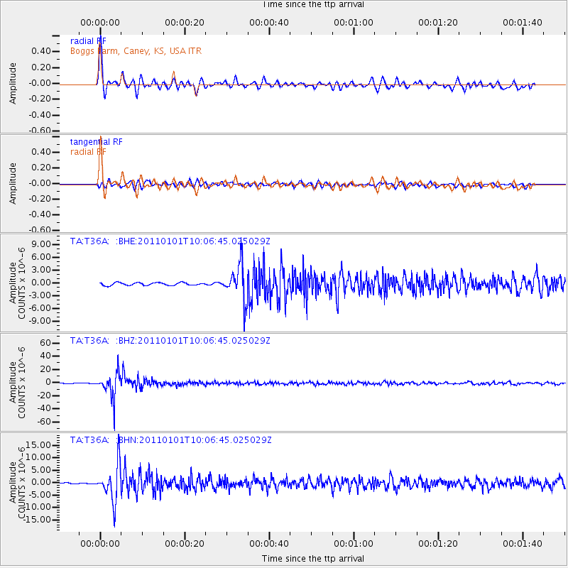
Signal To Noise
| Channel | StoN | STA | LTA |
| TA:T36A: :BHZ:20110101T10:06:45.025029Z | 47.116356 | 1.8214927E-5 | 3.8659456E-7 |
| TA:T36A: :BHN:20110101T10:06:45.025029Z | 23.019331 | 7.317868E-6 | 3.17901E-7 |
| TA:T36A: :BHE:20110101T10:06:45.025029Z | 13.319312 | 4.2293914E-6 | 3.1753828E-7 |
| Arrivals |
| Ps | 5.4 SECOND |
| PpPs | 18 SECOND |
| PsPs/PpSs | 23 SECOND |


