You are here: Home > Network List > TA - USArray Transportable Network (new EarthScope stations) Stations List
> Station N34A Lincoln, NE, USA > Earthquake Result Viewer
N34A Lincoln, NE, USA - Earthquake Result Viewer
| Earthquake location: |
Santiago Del Estero Prov., Arg. |
| Earthquake latitude/longitude: |
-26.8/-63.1 |
| Earthquake time(UTC): |
2011/01/01 (001) 09:56:58 GMT |
| Earthquake Depth: |
577 km |
| Earthquake Magnitude: |
6.8 MB, 7.0 MW, 7.0 MW |
| Earthquake Catalog/Contributor: |
WHDF/NEIC |
|
| Network: |
TA USArray Transportable Network (new EarthScope stations) |
| Station: |
N34A Lincoln, NE, USA |
| Lat/Lon: |
40.84 N/96.50 W |
| Elevation: |
401 m |
|
| Distance: |
74.1 deg |
| Az: |
334.284 deg |
| Baz: |
149.261 deg |
| Ray Param: |
0.050681587 |
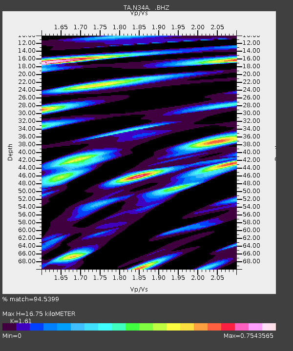
| Estimated Moho Depth: |
16.75 km |
| Estimated Crust Vp/Vs: |
1.61 |
| Assumed Crust Vp: |
6.498 km/s |
| Estimated Crust Vs: |
4.036 km/s |
| Estimated Crust Poisson's Ratio: |
0.19 |
|
| Radial Match: |
94.5399 % |
| Radial Bump: |
400 |
| Transverse Match: |
85.81494 % |
| Transverse Bump: |
400 |
| SOD ConfigId: |
346946 |
| Insert Time: |
2011-07-04 07:53:21.534 +0000 |
| GWidth: |
2.5 |
| Max Bumps: |
400 |
| Tol: |
0.001 |
|
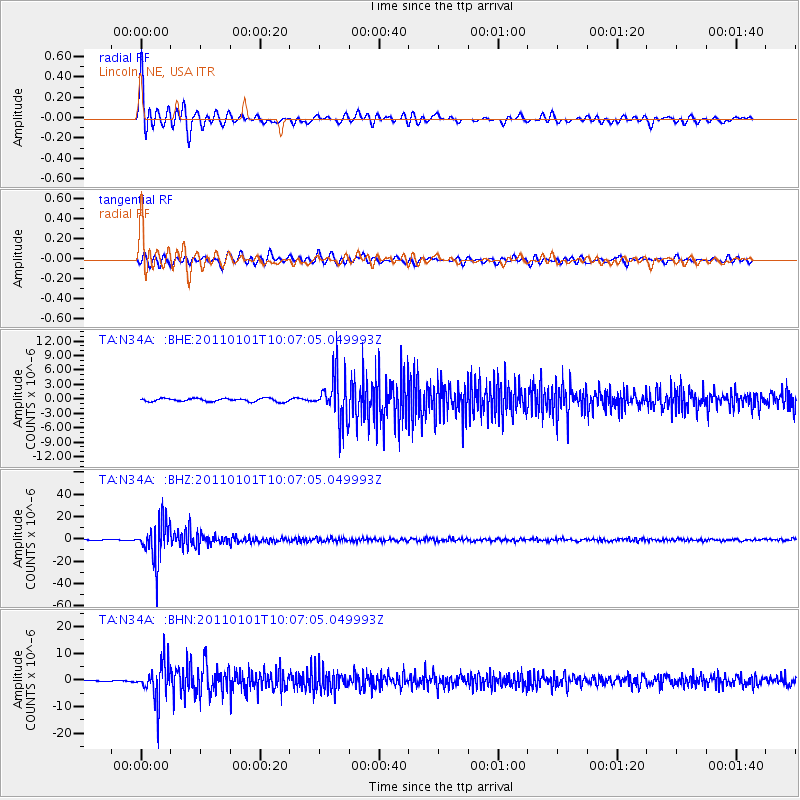
Signal To Noise
| Channel | StoN | STA | LTA |
| TA:N34A: :BHZ:20110101T10:07:05.049993Z | 74.0406 | 1.7954813E-5 | 2.4249957E-7 |
| TA:N34A: :BHN:20110101T10:07:05.049993Z | 27.688688 | 6.9583125E-6 | 2.5130524E-7 |
| TA:N34A: :BHE:20110101T10:07:05.049993Z | 14.025239 | 4.6396017E-6 | 3.3080372E-7 |
| Arrivals |
| Ps | 1.6 SECOND |
| PpPs | 6.5 SECOND |
| PsPs/PpSs | 8.1 SECOND |


