You are here: Home > Network List > XG92 - Rocky Mountain Front Stations List
> Station HSL Hartsel, CO > Earthquake Result Viewer
HSL Hartsel, CO - Earthquake Result Viewer
| Earthquake location: |
Svalbard Region |
| Earthquake latitude/longitude: |
76.2/7.2 |
| Earthquake time(UTC): |
1992/09/09 (253) 13:08:54 GMT |
| Earthquake Depth: |
24 km |
| Earthquake Magnitude: |
5.7 MB, 5.6 MS |
| Earthquake Catalog/Contributor: |
WHDF/NEIC |
|
| Network: |
XG Rocky Mountain Front |
| Station: |
HSL Hartsel, CO |
| Lat/Lon: |
39.03 N/105.75 W |
| Elevation: |
2713 m |
|
| Distance: |
57.6 deg |
| Az: |
301.873 deg |
| Baz: |
15.166 deg |
| Ray Param: |
0.063352086 |
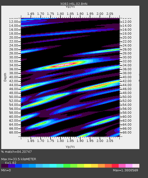
| Estimated Moho Depth: |
33.5 km |
| Estimated Crust Vp/Vs: |
1.82 |
| Assumed Crust Vp: |
6.159 km/s |
| Estimated Crust Vs: |
3.384 km/s |
| Estimated Crust Poisson's Ratio: |
0.28 |
|
| Radial Match: |
84.20747 % |
| Radial Bump: |
400 |
| Transverse Match: |
70.8978 % |
| Transverse Bump: |
400 |
| SOD ConfigId: |
3286 |
| Insert Time: |
2010-02-25 20:09:28.549 +0000 |
| GWidth: |
2.5 |
| Max Bumps: |
400 |
| Tol: |
0.001 |
|
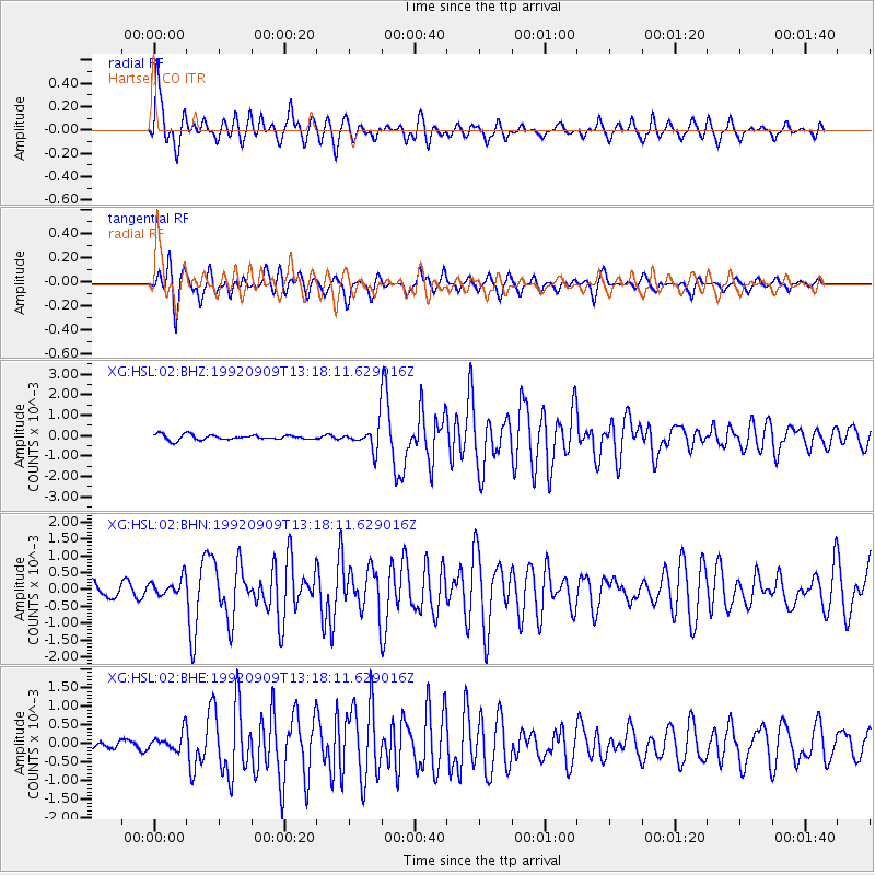
Signal To Noise
| Channel | StoN | STA | LTA |
| XG:HSL:02:BHN:19920909T13:18:11.629016Z | 1.4219333 | 2.677998E-4 | 1.8833499E-4 |
| XG:HSL:02:BHE:19920909T13:18:11.629016Z | 2.0861752 | 2.559603E-4 | 1.2269359E-4 |
| XG:HSL:02:BHZ:19920909T13:18:11.629016Z | 4.5712576 | 5.716037E-4 | 1.2504298E-4 |
| Arrivals |
| Ps | 4.7 SECOND |
| PpPs | 15 SECOND |
| PsPs/PpSs | 19 SECOND |


