You are here: Home > Network List > TA - USArray Transportable Network (new EarthScope stations) Stations List
> Station S37A Fort Scott, KS, USA > Earthquake Result Viewer
S37A Fort Scott, KS, USA - Earthquake Result Viewer

| Earthquake location: |
Santiago Del Estero Prov., Arg. |
| Earthquake latitude/longitude: |
-26.8/-63.1 |
| Earthquake time(UTC): |
2011/01/01 (001) 09:56:58 GMT |
| Earthquake Depth: |
577 km |
| Earthquake Magnitude: |
6.8 MB, 7.0 MW, 7.0 MW |
| Earthquake Catalog/Contributor: |
WHDF/NEIC |
|
| Network: |
TA USArray Transportable Network (new EarthScope stations) |
| Station: |
S37A Fort Scott, KS, USA |
| Lat/Lon: |
37.76 N/94.83 W |
| Elevation: |
260 m |
|
| Distance: |
70.8 deg |
| Az: |
333.834 deg |
| Baz: |
150.18 deg |
| Ray Param: |
0.052796066 |
| Estimated Moho Depth: |
44.0 km |
| Estimated Crust Vp/Vs: |
1.74 |
| Assumed Crust Vp: |
6.53 km/s |
| Estimated Crust Vs: |
3.764 km/s |
| Estimated Crust Poisson's Ratio: |
0.25 |
|
| Radial Match: |
96.416084 % |
| Radial Bump: |
217 |
| Transverse Match: |
92.416626 % |
| Transverse Bump: |
365 |
| SOD ConfigId: |
346946 |
| Insert Time: |
2011-07-04 08:00:24.825 +0000 |
| GWidth: |
2.5 |
| Max Bumps: |
400 |
| Tol: |
0.001 |
|
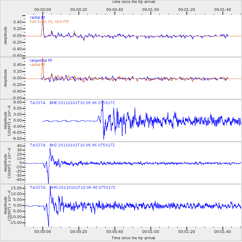
Signal To Noise
| Channel | StoN | STA | LTA |
| TA:S37A: :BHZ:20110101T10:06:46.075017Z | 59.70122 | 1.7049477E-5 | 2.8558003E-7 |
| TA:S37A: :BHN:20110101T10:06:46.075017Z | 18.8727 | 6.9366656E-6 | 3.6755029E-7 |
| TA:S37A: :BHE:20110101T10:06:46.075017Z | 17.15123 | 3.783563E-6 | 2.206001E-7 |
| Arrivals |
| Ps | 5.1 SECOND |
| PpPs | 18 SECOND |
| PsPs/PpSs | 23 SECOND |


