You are here: Home > Network List > TA - USArray Transportable Network (new EarthScope stations) Stations List
> Station J32A Parkston, SD, USA > Earthquake Result Viewer
J32A Parkston, SD, USA - Earthquake Result Viewer

| Earthquake location: |
Santiago Del Estero Prov., Arg. |
| Earthquake latitude/longitude: |
-26.8/-63.1 |
| Earthquake time(UTC): |
2011/01/01 (001) 09:56:58 GMT |
| Earthquake Depth: |
577 km |
| Earthquake Magnitude: |
6.8 MB, 7.0 MW, 7.0 MW |
| Earthquake Catalog/Contributor: |
WHDF/NEIC |
|
| Network: |
TA USArray Transportable Network (new EarthScope stations) |
| Station: |
J32A Parkston, SD, USA |
| Lat/Lon: |
43.37 N/97.85 W |
| Elevation: |
399 m |
|
| Distance: |
76.8 deg |
| Az: |
334.75 deg |
| Baz: |
148.478 deg |
| Ray Param: |
0.048941765 |
| Estimated Moho Depth: |
19.5 km |
| Estimated Crust Vp/Vs: |
1.60 |
| Assumed Crust Vp: |
6.498 km/s |
| Estimated Crust Vs: |
4.061 km/s |
| Estimated Crust Poisson's Ratio: |
0.18 |
|
| Radial Match: |
92.17149 % |
| Radial Bump: |
400 |
| Transverse Match: |
81.024956 % |
| Transverse Bump: |
400 |
| SOD ConfigId: |
346946 |
| Insert Time: |
2011-07-04 08:01:37.676 +0000 |
| GWidth: |
2.5 |
| Max Bumps: |
400 |
| Tol: |
0.001 |
|
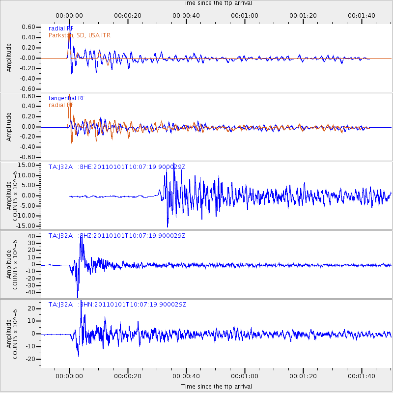
Signal To Noise
| Channel | StoN | STA | LTA |
| TA:J32A: :BHZ:20110101T10:07:19.900029Z | 57.004086 | 1.7869012E-5 | 3.1346897E-7 |
| TA:J32A: :BHN:20110101T10:07:19.900029Z | 26.020327 | 7.489343E-6 | 2.8782662E-7 |
| TA:J32A: :BHE:20110101T10:07:19.900029Z | 25.348076 | 5.1752104E-6 | 2.041658E-7 |
| Arrivals |
| Ps | 1.9 SECOND |
| PpPs | 7.6 SECOND |
| PsPs/PpSs | 9.4 SECOND |


